The US national airspace system is divided into classes designated by letters: A, B, C, D, E, and G. Each class has different entry requirements, equipment requirements, and weather minimums. Understanding airspace is not just about passing the written test — it's about knowing your rights and responsibilities every time you fly.
| Class | Location | Entry requirement | VFR vis | Cloud clearance |
|---|---|---|---|---|
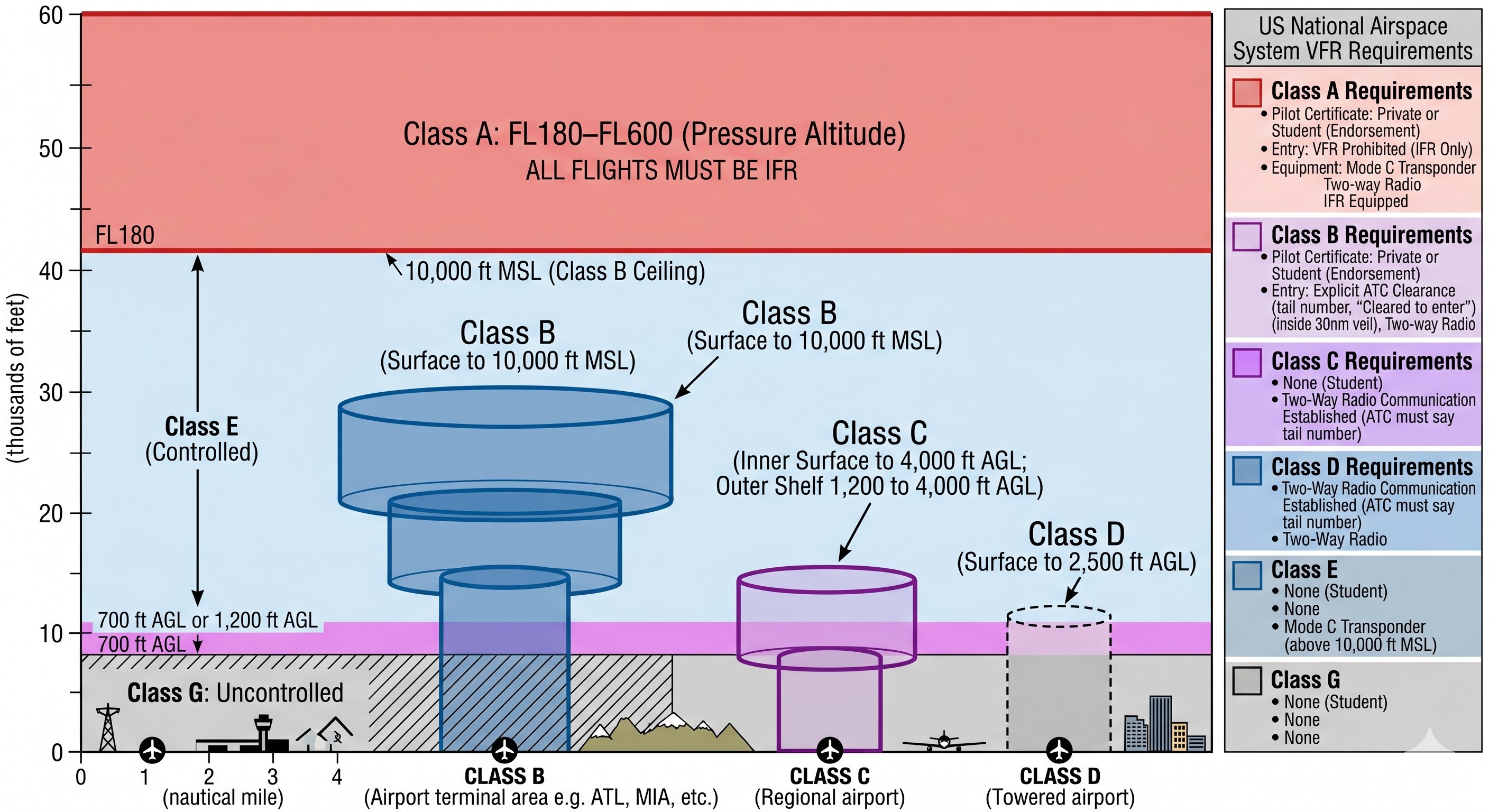
| Class A | 18,000–60,000 ft MSL | IFR clearance required | N/A (IFR only) | N/A |
| Class B | Busiest airports (surface–10,000 ft) | ATC clearance + Mode C | 3 SM | Clear of clouds |
| Class C | Busy airports (surface–4,000 AGL) | Two-way radio + Mode C | 3 SM | 500 below, 1000 above, 2000 horiz |
| Class D | Towered airports (surface–2,500 AGL) | Two-way radio communication | 3 SM | 500 below, 1000 above, 2000 horiz |
| Class E | Most controlled airspace | None for VFR | 3 SM (below 10k) | 500 below, 1000 above, 2000 horiz |
| Class G | Uncontrolled airspace | None | 1 SM (day, under 1200 AGL) | Clear of clouds |
Class A — The high-altitude highway
Class A airspace covers the entire contiguous US from 18,000 feet MSL up to and including 60,000 feet MSL (Flight Level 600). All operations in Class A are under IFR — no VFR flight is permitted. You won't encounter Class A as a student pilot or new private pilot, but you need to know it exists and where it starts.
The transition altitude into Class A (18,000 ft MSL) is significant: below it, altimeters are set to local altimeter setting. At and above 18,000 ft, all aircraft set altimeters to 29.92 inHg and report altitude as Flight Levels (FL180, FL350, etc.).
64 free PPL ground school videos on YouTube. Also offers a premium interactive course at freepilottraining.net with 700+ practice questions and a written exam endorsement.
Class B — The busiest airports
Class B airspace surrounds the nation's busiest commercial airports — think Atlanta, Chicago O'Hare, LAX, Dallas/Fort Worth, JFK. It extends from the surface to 10,000 feet MSL and is depicted on sectional charts as solid blue circles, often described as looking like an upside-down wedding cake because the outer rings start at higher altitudes than the inner rings.
What you need to enter Class B
- ATC clearance — you must receive the specific words "cleared into the Class Bravo." Hearing only "N12345, radar contact" or "standby" does not authorize entry.
- Mode C transponder — or Mode S with altitude encoding
- Two-way radio
- Private Pilot Certificate or higher — student pilots may NOT fly solo in Class B without specific training and CFI endorsement for that specific Class B airspace
The 30 nm Mode C veil
Even if you never enter Class B airspace, you must have a Mode C transponder within 30 nautical miles of any Class B primary airport, from the surface up to 10,000 feet MSL. This applies even to airports that are not themselves in Class B — if they're within 30 nm of a Class B primary, you need Mode C.
VFR weather minimums in Class B
Class B has unique minimums: 3 statute miles visibility and clear of clouds. There is no specific cloud clearance distance required — you just cannot be in a cloud. This is less restrictive than other controlled airspace in terms of cloud clearance but requires a clearance to enter.
Class C — Moderate-traffic airports
Class C surrounds airports with a control tower, radar approach control, and a certain level of commercial traffic — think Raleigh-Durham, Rochester, Albuquerque, Tucson. It extends from the surface to 4,000 feet AGL above the airport in a 5 nm inner ring and from 1,200 feet AGL to 4,000 feet AGL in a 10 nm outer ring. On sectional charts: solid magenta circles.
What you need to enter Class C
- Two-way radio communications established — unlike Class B, you don't need a clearance. You just need to establish two-way communications. If the controller says "N12345, standby," you've established communications and may proceed unless told otherwise.
- Mode C transponder with altitude encoding
- No specific pilot certificate requirement — students may fly in Class C
The Class C radio call
When approaching Class C, call approach control before entering: "Raleigh Approach, Cessna N12345, 10 miles northeast, 3,500, landing Raleigh-Durham." If they respond with your call sign in any way, two-way communications are established. If they say "N12345, standby," you may proceed — standby acknowledges your call. If the controller doesn't use your call sign, you have not established communications and may not enter.
Class D — Towered airports
Class D surrounds airports with an operating control tower but no radar approach control. It extends from the surface to approximately 2,500 feet AGL in a roughly 5 nm radius. On sectional charts: dashed blue circles. Most smaller towered airports — regional airports, suburban airports — are Class D.
What you need to enter Class D
- Two-way radio communications established with the tower before entering the airspace
- No transponder required (though strongly recommended)
- No specific pilot certificate required
When the tower is closed (many Class D airports are part-time towers), the airspace reverts to Class E or G, and you operate under the rules of that lower class. Check the chart supplement or NOTAMs for tower hours.
Class D radio call: "Millville Tower, Cessna N12345, 5 miles north, 2,000, landing with information Bravo." The controller will respond with landing instructions. Unlike Class B, no explicit clearance is required — just established two-way communications.
Class E — The workhorse of controlled airspace
Class E is controlled airspace that isn't A, B, C, or D. It covers most of the US airspace where you'll actually fly cross-country. Class E starts at different altitudes depending on where you are:
- 700 feet AGL — the magenta shading on sectional charts. Typically surrounds airports with instrument approaches but no control tower. The shading shows where Class E begins at 700 ft to protect IFR aircraft on approach.
- 1,200 feet AGL — the default floor of Class E in most of the US (shown as the absence of shading between the 700 ft magenta zones and the blue 14,500 ft transition)
- Surface — depicted as dashed magenta lines around non-towered airports with instrument approaches. Class E extends to the surface here.
- 14,500 feet MSL — Class E floor for most of the US above the lower controlled airspace until Class A begins at 18,000 ft
No entry requirement for VFR
VFR pilots can fly in Class E without any radio calls, clearances, or special equipment (though a transponder is required above 10,000 ft MSL). The weather minimums are 3 SM visibility and 500 ft below, 1,000 ft above, 2,000 ft horizontal from clouds.
Class G — Uncontrolled airspace
Class G is the airspace below Class E — typically from the surface up to 700 or 1,200 feet AGL depending on location. It is uncontrolled: no ATC services, no radio requirements, minimal equipment requirements. The weather minimums in Class G are the most permissive of any airspace class.
Class G VFR minimums — day
- Below 1,200 ft AGL: 1 SM visibility, clear of clouds
- Above 1,200 ft AGL but below 10,000 ft MSL: 1 SM visibility, 500 below / 1,000 above / 2,000 horizontal
- Above 10,000 ft MSL: 5 SM visibility, 1,000 ft below / 1,000 ft above / 1 SM horizontal
Class G VFR minimums — night
At night, Class G minimums increase: 3 SM visibility and 500 ft below / 1,000 ft above / 2,000 ft horizontal cloud clearance at all altitudes below 10,000 ft. Night operations in Class G with low ceilings are genuinely dangerous regardless of legality.
Special use airspace
Beyond the lettered classes, several special use airspace types appear on sectional charts and require awareness:
- Prohibited areas (P) — flight absolutely prohibited. P-56 over Washington DC. Non-negotiable.
- Restricted areas (R) — requires prior authorization from controlling agency. Often active only part-time — check NOTAMs.
- MOAs (Military Operations Areas) — IFR aircraft need clearance; VFR pilots should contact the controlling agency or FSS for status before entering. Military aircraft may be operating at high speed.
- Warning areas (W) — over international waters, similar hazards to restricted areas but outside US jurisdiction. Exercise extreme caution.
- Alert areas (A) — high volume of pilot training. Both military and civilian aircraft are equally responsible for collision avoidance.
- TFRs — temporary restrictions for VIP movements, disasters, sporting events. Check 1800wxbrief.com before every flight.
How to use this knowledge in the cockpit
Before every flight, look at your route on a sectional chart and identify: what airspace classes will you penetrate? Are there Class B shelves overhead that require Mode C? Any MOAs or restricted areas? Any TFRs? Is your destination airport Class D, E, or G when the tower closes?
The sectional chart legend is your reference. Color coding: blue for Class B and towered airports, magenta for Class C and non-towered airports with approaches, dashed blue for Class D, dashed magenta for surface Class E. The more cross-countries you fly with the chart in your lap, the more automatic airspace recognition becomes.
Practice tool: Use our go/no-go weather tool to check VFR minimums for different airspace classes. And use our VFR minimums reference for a quick chart of all class requirements side by side.