Airspace Classification
- The six classes of airspace and what each means for drone pilots
- How to read sectional charts to determine airspace around you
- The LAANC system and how to get real-time airspace authorization
- Temporary Flight Restrictions (TFRs) and how to identify them
- Special use airspace: MOAs, restricted areas, and prohibited areas
- The B4UFLY app and other tools for airspace awareness
- Consequences of unauthorized airspace incursions
- Remote ID and airspace awareness
Lesson 1 — Why Airspace Matters for Drone Pilots
Airspace is the single most tested topic on the Part 107 knowledge test. Understanding it isn't just regulatory compliance — it directly affects where you can fly, when you can fly, and what authorization you need. Drone pilots share airspace with manned aircraft operating under instrument flight rules (IFR) and visual flight rules (VFR). A mid-air collision between a drone and a manned aircraft is catastrophic, which is why airspace management is taken seriously by both the FAA and law enforcement.
The FAA classifies airspace into six classes (A through G) based on operational complexity, traffic density, and the level of ATC services provided. Each class has specific entry requirements, equipment needs, and operating rules. For drone pilots, the most critical distinction is which airspace classes require prior authorization before flight, and which allow flight without advance notice.
The default rule under Part 107 is that drone operations in Class G (uncontrolled) airspace at or below 400 feet AGL are permitted without prior ATC authorization. All other classes require authorization through LAANC or a manual FAA Drone Authorization process before flight.
Shared Airspace Incidents
The FAA receives thousands of drone sightings near manned aircraft each year. While most are benign (small drones spotted by pilots that posed no actual collision risk), several incidents have resulted in structural damage to manned aircraft and near-misses that triggered emergency maneuvers. In 2017, a Canadian drone struck an ATR 42 turboprop during approach to Jean-Lesage International Airport in Quebec — the first confirmed collision between a drone and a commercial aircraft in North America. The impact damaged the leading edge of the wing. Nobody was seriously injured, but the incident demonstrated that drone-aircraft collisions are a real, not theoretical, risk.
The physics are sobering: a 2-pound drone at 30 mph relative to an aircraft traveling at 130 mph creates a relative velocity of 160 mph. At that speed, even a small object can cause serious structural damage — particularly to engines, windscreens, and control surfaces. Drone operators who fly near airports without authorization aren't just breaking the law — they're creating genuine hazards to the occupants of manned aircraft.
How the FAA Detects Unauthorized Drones
The FAA and law enforcement use several systems to detect unauthorized drone operations. Remote ID (when broadcast) can be detected by portable receivers. Radar systems at major airports can detect drones. Multiple reports from pilots and ATC are logged and investigated. The FAA's UAS Safety Team tracks trends and identifies repeat violators. Remote ID makes enforcement significantly more effective — the operator's location is broadcast with the aircraft, making it straightforward to locate violators once the signal is detected.
Lesson 2 — Class A Airspace
Class A airspace extends from 18,000 feet MSL (mean sea level) up to 60,000 feet MSL (Flight Level 600). All operations in Class A are conducted under Instrument Flight Rules (IFR) — pilots must be instrument rated, aircraft must be properly equipped, and ATC clearance is required for entry.
For drone pilots, Class A is essentially irrelevant in practice. The Part 107 maximum altitude of 400 feet AGL means you will never fly anywhere near Class A. However, it appears on the knowledge test, and you need to know that Class A begins at 18,000 feet MSL and that all flight within it requires IFR clearance.
Why It Appears on the Part 107 Test
Although drone pilots will never fly in Class A airspace under normal Part 107 operations, the FAA includes it in the knowledge test for two reasons. First, comprehensive airspace knowledge demonstrates that a pilot understands the full structure of the National Airspace System (NAS) — not just the portions most relevant to drones. Second, some questions on the test present airspace scenarios where you need to identify what class of airspace applies at a given altitude, and Class A is the ceiling that caps the described airspace structure.
Class A begins at 18,000 feet MSL and extends to FL600 (60,000 feet). All operations within Class A are IFR — instrument flight rules. Pilots must have an instrument rating, aircraft must have functioning IFR equipment, and ATC clearance is required before entering. Airlines, business jets, and military operations predominantly use Class A. The term "flight level" (FL) is used above 18,000 feet — FL180 is 18,000 feet, FL350 is 35,000 feet (altimeter set to standard 29.92 inHg).
Lesson 3 — Class B Airspace
Class B airspace surrounds the nation's busiest airports — major airline hubs like LAX, JFK, O'Hare, Hartsfield-Jackson, and similar facilities. It extends from the surface up to 10,000 feet MSL and is shaped like an upside-down wedding cake — multiple layers of varying radii centered on the primary airport. The innermost circle typically has the largest vertical extent; outer rings start at progressively higher altitudes.
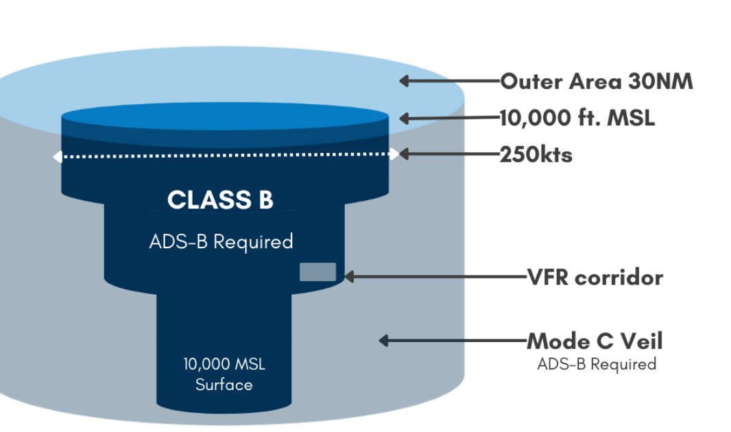
Class B airspace structure — the inverted wedding cake shape with ADS-B required throughout
Class B boundaries are depicted on sectional charts as solid blue lines. The notation "B" with altitude numbers indicates the floor and ceiling of each ring. For example, "40/SFC" means that layer extends from the surface to 4,000 feet MSL. "40/15" means from 1,500 to 4,000 feet MSL.
Drone operations in Class B require authorization. LAANC provides near-real-time authorization for many Class B areas with grid-based altitude approvals. Some Class B areas are not covered by LAANC and require manual FAA authorization through DroneZone, which can take days to weeks. Always check before flying near major airports.
Flying an unauthorized drone in Class B airspace can interfere with instrument approach procedures and cause go-arounds or aborted approaches. The FAA takes unauthorized Class B incursions extremely seriously — enforcement action is virtually certain if detected.
Reading Class B on Sectional Charts
Class B airspace on a sectional chart looks like concentric rings (the wedding cake) centered on the primary airport. Each ring segment shows the floor and ceiling altitude in hundreds of feet MSL. The notation is always ceiling/floor — so "100/SFC" means the airspace extends from the surface to 10,000 feet MSL. "100/40" means from 4,000 to 10,000 feet MSL.
For drone pilots, the most important detail is where Class B airspace begins at the surface (SFC). Surface Class B extends directly around the primary airport — this is where LAANC authorization is most restrictive and where automatic authorization altitudes are often zero. If you see "SFC" in the Class B notation for the area you want to fly in, expect manual authorization to be required or very low LAANC ceilings.
Drone Operations Near Major Airports in Practice
Most major airports are surrounded by what drone pilots call "red zones" — areas where LAANC automatic authorization ceilings are 0 feet. In these areas, you cannot get near-real-time authorization for any altitude; you must apply for manual authorization through DroneZone. Manual authorization near busy airports is rarely granted for non-emergency, non-essential operations. The FAA's position is that the operational benefits to a commercial drone flight rarely outweigh the risks of adding traffic near major airport approach and departure corridors.
If your operation genuinely requires work near a major airport (construction inspection, infrastructure work), document the specific safety case thoroughly, identify time windows with the least traffic impact, and coordinate with the TRACON (Terminal Radar Approach Control) facility if applicable. Building a relationship with the local FSDO (Flight Standards District Office) before submitting applications can improve outcomes for complex operations.
Lesson 4 — Class C and Class D Airspace
Class C airspace surrounds airports with a moderate level of commercial service — regional airports with control towers and radar approach control. It typically extends from the surface to 4,000 feet AGL within a 5 nautical mile (NM) radius of the airport, with an outer ring from 1,200 to 4,000 feet AGL extending from 5 to 10 NM. Class C is depicted on sectional charts as magenta (pink) solid circles.
Within Class C, two-way radio communication is required before entry for manned aircraft, and drone operators must obtain LAANC authorization. Class C airports include places like San Jose (KSJC), Portland (KPDX), and hundreds of regional airports across the country.
Class D airspace surrounds airports with control towers that have less traffic than Class C facilities. It typically extends from the surface to 2,500 feet AGL within approximately a 4-5 NM radius. Class D is depicted on sectional charts as blue dashed circles. It requires radio communication for manned aircraft and LAANC authorization for drone pilots. Class D is extremely common — thousands of smaller airports with towers have Class D airspace.
Two-Way Communication Requirement
For manned aircraft, Class C requires two-way radio communication — the controller must acknowledge the aircraft by name (not just "stand by"). Simply calling the controller and hearing "stand by" doesn't satisfy the requirement. For drone pilots, this manned-aircraft requirement is informative context — it explains why Class C airports have active radar approach control and why unauthorized drone operations in Class C are quickly noticed by ATC watching their radar scope.
Drone pilots don't need to establish radio communication to enter Class C, but understanding that Class C airports have approach and departure radar coverage helps contextualize why the authorization requirement exists. ATC at Class C airports can see radar returns that may include larger drones, and reports of unauthorized drone activity are taken seriously and investigated.
Non-Towered Airports and Class E
Many non-towered airports have Class E airspace that extends to the surface or begins at 700 feet AGL around them — even without a control tower. This is because aircraft flying instrument approaches to non-towered airports still need protected airspace. The Class E surface area or transition area protects IFR traffic during low-visibility instrument approaches. Drone pilots often discover this when they check B4UFLY near a small airport with no tower and find that authorization is still required — because Class E surface exists there.
A dashed magenta circle on a sectional chart indicates Class E that extends to the surface (like a mini Class D without the tower). A magenta vignette/shading indicates Class E starting at 700 feet AGL. Both require authorization for drone operations within them, though LAANC is often available at these smaller airports with reasonable ceiling limits.
| Class | Typical Airports | Chart Symbol | Drone Authorization |
|---|---|---|---|
| B | Major airline hubs | Solid blue lines | LAANC or manual |
| C | Regional commercial | Solid magenta circles | LAANC or manual |
| D | Towered airports | Dashed blue circles | LAANC or manual |
| E | Transition/approach | Various | Sometimes required |
| G | None (uncontrolled) | No symbol | Not required (≤400ft) |
Lesson 5 — Class E and Class G Airspace
Class E airspace is controlled airspace that isn't Class A, B, C, or D. It fills in the gaps — transition areas around airports, federal airways, and the vast majority of the airspace above 1,200 feet AGL across the continental US. Class E exists primarily to protect IFR traffic operating in cloud or reduced visibility conditions.
Class E can start at different altitudes depending on location. In many areas, Class E starts at 1,200 feet AGL. Near airports, it may start at 700 feet AGL (depicted as a magenta vignette/shading on sectionals) or even at the surface (depicted as a dashed magenta circle or as the area just outside Class D). The lowest level of Class E (700 AGL or surface) around airports is where drone pilots most commonly need authorization — many non-towered airports have Class E surface extensions.
Class G airspace is uncontrolled airspace — below Class E in most areas, typically from the surface up to 700 or 1,200 feet AGL depending on location. No ATC services are provided. For drone pilots, Class G is the "free to fly" zone — Part 107 operations below 400 feet AGL in Class G do not require prior ATC authorization. Most drone flights outside of airport areas occur in Class G.
Where Class G Exists in Practice
Class G is the default airspace — wherever Class A through E doesn't exist, Class G fills in. In rural areas away from airports, Class G typically extends from the surface up to 1,200 feet AGL, where Class E begins. In areas near airports but outside Class D or C, Class G may only extend from the surface to 700 feet AGL before Class E begins (where the magenta shading appears on a sectional).
The practical implication: in most rural areas far from airports, drone pilots flying below 400 feet AGL are almost certainly in Class G and need no authorization. In areas close to airports or under approach/departure paths, even Class G airspace at low altitudes may have traffic. Visual awareness of potential aircraft in your area is always required, regardless of airspace class.
The 400-Foot Buffer Above Structures
When flying within 400 feet of a structure, you can fly up to 400 feet above the structure's highest point — even if that height puts you in Class E or higher controlled airspace. This exception is codified in Part 107 for legitimate inspection and maintenance work. However, the authorization requirement for controlled airspace still applies to the flight itself, even if the altitude limit is raised by the structure exception. If the structure is in Class D airspace, you still need LAANC authorization — the structure exception only affects the altitude limit, not the airspace authorization requirement.
Lesson 6 — LAANC: Low Altitude Authorization and Notification Capability
LAANC (pronounced "lance") is the FAA's automated system for providing near-real-time airspace authorization to drone pilots. It replaced the old manual authorization process that required submitting requests through DroneZone and waiting days or weeks for approval. With LAANC, authorization is typically granted in seconds through a participating app.
LAANC divides controlled airspace around airports into a grid of squares, each with an assigned maximum altitude at which automatic authorization is available. A grid square showing "200" means LAANC can automatically authorize flight up to 200 feet AGL in that area. A square showing "0" means no automatic authorization is available — you must apply for manual authorization through DroneZone. Some areas have no LAANC coverage at all and require manual authorization regardless.
LAANC is accessible through multiple FAA-approved apps including AirMap, Kittyhawk, DJI Fly, Aloft (formerly AirMap), and Wing. The authorization is tied to a specific time window, location, and altitude. Flying outside those parameters — even slightly — means you are no longer operating under your authorization. Always fly within the parameters of your LAANC authorization.
LAANC authorization only allows you to fly in controlled airspace at or below the grid altitude for that area. It does NOT waive other Part 107 requirements like daylight-only operations or visual line of sight. If you need to fly at night or beyond visual line of sight, you need a separate waiver in addition to airspace authorization.
How LAANC Grids Are Determined
LAANC ceiling grids are determined by the FAA's analysis of approach and departure procedures, radar coverage, and traffic density at each airport. Areas with frequent low-altitude instrument approach procedures — final approach courses and departure routes — typically have lower LAANC ceilings or zero ceilings. Areas to the side of the airport away from the runway extended centerlines often have higher LAANC ceilings because aircraft are not operating at low altitude there.
LAANC ceilings are not negotiable — if your mission requires flight above the LAANC ceiling for an area, you must use the manual authorization process regardless of operational need. Attempting to fly above your LAANC-authorized altitude violates the terms of the authorization and constitutes unauthorized airspace entry. Always verify the specific ceiling granted for your location before flight — the ceiling varies across the grid and at the boundaries between LAANC grid squares.
LAANC Authorization Duration and Cancellation
LAANC authorizations are time-bound — typically a few hours per authorization. If your operation extends beyond the authorization window, you need a new authorization. Some apps allow you to extend in real time; others require a new application. LAANC authorizations can also be automatically cancelled if an active TFR is issued over your operating area after your authorization was granted — the TFR supersedes the LAANC. Check for TFRs at the beginning of every operation, not just during pre-flight planning hours earlier.
Lesson 7 — TFRs and Special Use Airspace
Temporary Flight Restrictions (TFRs) are notices that temporarily restrict flight in a defined area for specific reasons: emergency response, presidential movement (the most common large TFR), VIP movements, space launches, stadiums during major sporting events, and disaster areas. TFRs are issued via NOTAM (Notice to Air Missions) and have a defined location, altitude range, and time period.
The most common TFR drone pilots encounter is the stadium TFR — a 3 NM radius, surface to 3,000 feet MSL, around major league baseball, NFL, NCAA Division I football, NASCAR, and similar events from 1 hour before to 1 hour after the event. Flying an unauthorized drone over a stadium can result in criminal prosecution. The presidential TFR prohibits all unauthorized flight within 30 NM (outer ring) and 10 NM (inner ring) of the president's location.
Special Use Airspace (SUA) includes several types with varying levels of restriction:
How to Check TFRs
The definitive TFR check is at notams.faa.gov — look for FDC NOTAMs containing the text "FLIGHT RESTRICTIONS." Many drone apps pull TFR data from this source, but there can be delays between TFR issuance and appearance in third-party apps. For time-sensitive operations, check the FAA NOTAM system directly rather than relying solely on app data.
Graphical TFR depictions are available at tfr.faa.gov, which shows TFRs on a map for easy geographic reference. This is the fastest way to check if any TFRs are active in your planned flying area. The map is not a substitute for reading the actual NOTAM — always read the full NOTAM to understand the exact altitude range, lateral boundaries, and permitted activities (some TFRs have exceptions for certain operators).
National Defense Airspace and Drones
Certain areas have permanent airspace restrictions related to national defense or security. The Washington DC SFRA (Special Flight Rules Area) — a 30-mile radius around Reagan National Airport — has strict entry requirements and the innermost FRZ (Flight Restricted Zone — 15-mile radius) requires special authorization that is very difficult to obtain for recreational or commercial purposes. Washington DC's prohibited areas (P-56A over the White House, P-56B over the Capitol) are no-fly zones with serious enforcement consequences.
Other sensitive facilities — nuclear power plants, military installations, and critical infrastructure — may have NOTAMs, TFRs, or standing airspace restrictions. The FAA's UAS Data Delivery Service (UDDS) and tools like AirMap incorporate these restrictions. When flying near any facility that has obvious security sensitivity, research the restrictions before arrival rather than discovering them on site.
- Prohibited Areas (e.g., P-56 over Washington DC) — flight is absolutely prohibited at all times. No waivers or authorizations available.
- Restricted Areas — flight requires permission from the controlling agency. Used for military operations, weapons testing, and hazardous activities.
- Military Operations Areas (MOAs) — military training occurs here. Not prohibited for civilian aircraft but may be hazardous during active periods.
- Warning Areas — similar to restricted areas but extend over international waters.
- National Security Areas (NSAs) — voluntary avoidance requested due to national security concerns.
Lesson 8 — Airspace Tools for Drone Pilots
Several tools help drone pilots understand and navigate airspace. The B4UFLY app (iOS and Android), developed by the FAA, provides a simple go/no-go check for any location. Enter your planned location and the app shows whether flight is permitted, what restrictions apply, and whether authorization is needed. It integrates TFRs, airspace classifications, and special use areas.
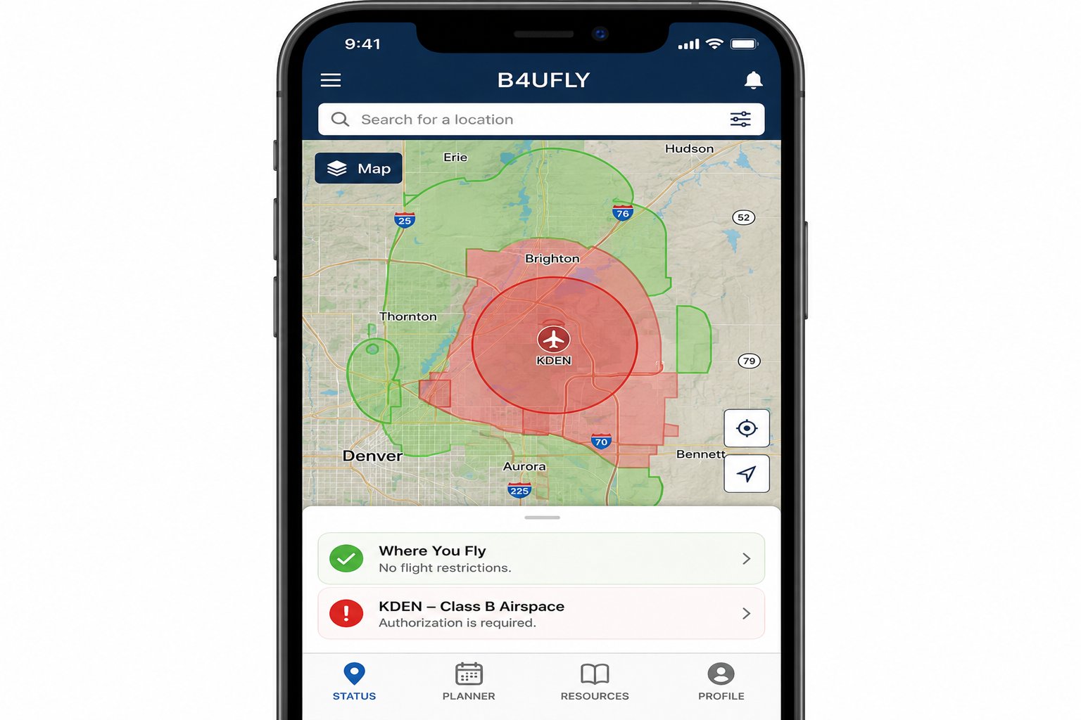
B4UFLY app showing Class B airspace restriction around KDEN — red zones require LAANC authorization
Sectional charts are the official FAA charts used by all pilots. While primarily designed for manned aircraft, they're the authoritative source for airspace information. The Part 107 test uses sectional chart excerpts — you must be able to identify airspace boundaries, decode altitude notations, and find airport information from a sectional. Practice reading sectionals at skyvector.com, which has free online sectional charts.
NOTAM systems provide time-sensitive flight information including TFRs, runway closures, and equipment outages. The FAA's official NOTAM system is at notams.faa.gov. Many drone apps pull NOTAM data automatically, but for important missions, verify TFRs directly through the FAA system before every flight.
Developing a Pre-Flight Airspace Routine
Professional drone operators develop a consistent airspace check routine that becomes second nature before every flight. A recommended sequence: (1) Check B4UFLY for basic go/no-go at your location. (2) Check the FAA NOTAM system at notams.faa.gov for active TFRs. (3) Open your primary drone app (Aloft, Kittyhawk, or similar) and confirm the LAANC ceiling for your specific grid squares. (4) Obtain LAANC authorization if operating in controlled airspace. (5) Cross-reference the app's airspace display with a sectional chart excerpt if operating near airspace boundaries.
This sequence takes 5-10 minutes and should be non-negotiable. The routine is most important precisely when it feels least necessary — clear sky, familiar location, "I've flown here dozens of times" are the conditions under which pilots skip checks and discover that a TFR was issued overnight. Consistent routine protects against complacency.
When Airspace Changes Mid-Flight
TFRs can be issued while you're actively flying — presidential movement TFRs can appear with very short notice, and emergency TFRs for wildfires, disasters, or security incidents can be issued within minutes. If a TFR is issued over your operating area during flight, the safest action is to land immediately if you can do so safely, or maneuver out of the TFR area if you're near the boundary.
This is one reason to keep the drone app open on your phone or tablet during flight rather than just at pre-flight — several apps push notifications when TFRs are issued near your location. Having situational awareness of dynamic airspace changes during active operations is a component of the continuing airspace vigilance that Part 107 pilots are expected to maintain.