Radio Communications & ATC
- When drone pilots need to contact ATC
- How to communicate with a control tower
- Reading and understanding NOTAMs
- Airport traffic areas and airport operations
- Phonetic alphabet and aviation communication standards
- Radio equipment and frequencies used in aviation
Lesson 1 — Do Drone Pilots Need to Use Radios?
Part 107 does not require drone pilots to carry or use a radio during normal operations. However, there are important situations where radio communication with ATC is either required, strongly recommended, or simply good practice. Understanding when and how to communicate with ATC is a Part 107 knowledge test topic and a professional competency.
Situations where radio contact with ATC is appropriate or required: when operating under a LAANC authorization near a towered airport, when an emergency situation develops, when ATC calls you on a published frequency (rare but possible), and when voluntarily coordinating with a tower to enhance safety in their traffic area. Some LAANC authorizations in complex airspace include a recommendation to monitor the local tower frequency — not required, but professional.
When Radio Contact Is Strongly Recommended
Even when not legally required, proactive communication with ATC can prevent conflicts and build goodwill. If you're operating near a busy non-towered airport, monitoring the CTAF and listening to pilot position reports gives you situational awareness about traffic that might be in your area. You can hear departures and arrivals without transmitting yourself. If you hear traffic that will be near your operating altitude and position, you can choose to land temporarily until the traffic clears.
For operations near heliports — common in urban areas near hospitals, news stations, and corporate facilities — monitoring relevant frequencies provides advance warning of helicopter traffic that may operate at very low altitudes without following standard fixed-wing traffic patterns. Helicopters in busy urban areas often operate under IFR or in specific corridors that bring them through areas where drones may be operating.
ATC Communication Expectations
If ATC contacts you during a drone operation (increasingly possible as Remote ID and radar detection improve), respond professionally and cooperatively. Provide your location, altitude, and nature of operation when asked. If ATC requests that you terminate the flight, comply immediately — ATC has the authority to direct aircraft to terminate operations when safety requires it. Arguing with ATC during an active situation is never appropriate and can escalate minor situations into enforcement proceedings.
Lesson 2 — Airport Types and Traffic Patterns
Understanding airport operations helps drone pilots anticipate aircraft behavior and avoid conflicts. Towered airports have an operating control tower during published hours. ATC directs all traffic — arrival, departure, and ground. Non-towered airports (also called uncontrolled airports) have no operating tower. Pilots self-announce their intentions on the Common Traffic Advisory Frequency (CTAF) and maintain separation using see-and-avoid.
The traffic pattern is the rectangular flight path that aircraft fly when arriving and departing. It consists of: departure leg (straight out after takeoff), crosswind leg (90° turn), downwind leg (parallel to runway, opposite direction), base leg (90° turn toward runway), and final approach (aligned with runway for landing). Standard pattern altitude is 1,000 feet AGL. Drone pilots operating near airports must be aware of where pattern traffic will be — even in Class G airspace near a non-towered airport, aircraft in the traffic pattern could be at 1,000 feet AGL over your operating area.
Reading Airport Information on Sectional Charts
Sectional charts display a significant amount of information about airports in compact notation. The airport data block typically shows: airport name, field elevation (in feet MSL), runway length (thousands of feet, longest runway), lighting availability, control tower frequency, and ATIS frequency if applicable. For drone pilots, the most important elements are the airport symbol (which identifies the airspace class) and the elevation (needed for calculating AGL operations near the airport).
Hard-surface runway airports (Class B, C, D, or E towered) are depicted with a specific symbol that includes runway orientation lines. Airports with control towers have their tower frequency shown in a box near the airport symbol. Learning to quickly extract relevant information from sectional chart airport depictions is a tested Part 107 skill — practice with actual sectional charts at skyvector.com or the FAA's aeronautical chart user guide.
Segmented Circle and Traffic Pattern Indicators
Many non-towered airports have a segmented circle — a ground-based wind direction and traffic pattern indicator visible from the air. The segmented circle includes L-shaped extensions that indicate the direction of the traffic pattern legs. For drone pilots, the segmented circle location marks the airport reference point used for airspace distance calculations. Understanding that non-towered airports have standardized traffic pattern procedures (left-hand turns unless otherwise specified) helps predict where aircraft will be during arrivals and departures.
Lesson 3 — NOTAMs
NOTAMs (Notices to Air Missions, formerly Notices to Airmen) are official FAA notices about conditions or changes that affect flight. They include: TFRs (Temporary Flight Restrictions), runway closures, navigational aid outages, airspace changes, and construction or obstacles that may affect flight. Part 107 pilots are required to check for applicable NOTAMs before every flight.
NOTAMs are found at notams.faa.gov. The FAA redesigned the NOTAM system in 2023 with improved plain-language formatting, making them more readable than the old cryptic all-caps format. Key NOTAM types relevant to drone pilots:
- !FDC NOTAMs — Regulatory changes, TFRs issued by the FAA Flight Data Center
- !GPS NOTAMs — GPS signal testing or interference in an area (critical for drone operations)
- !Stadium NOTAMs — Issued for major sporting events
- !Airspace NOTAMs — Temporary airspace restrictions for emergency operations, VIP movement
Many drone apps pull NOTAM data automatically, but for complex or high-stakes missions, verify directly through the FAA NOTAM system. App data may have a delay, and some NOTAMs may not be captured in third-party systems.
Decoding NOTAM Format
Modern NOTAMs use a more readable plain-language format since the FAA's 2023 NOTAM system overhaul. However, older-format NOTAMs still appear in the system and understanding the coded format is tested on Part 107. Key NOTAM elements: the facility identifier (airport ICAO code), the subject code (e.g., OB for obstacle, AD for aerodrome), altitude information (surface, AGL, or MSL in feet), and the effective time (from/to, in UTC/Zulu).
Example NOTAM decoding: "!ORD 03/047 ORD OB CRANE 1.2 NM NE ORD 1120 FT MSL (820 FT AGL) 2103151400-2104302359" translates to: at O'Hare International Airport, obstacle NOTAM, a crane located 1.2 nautical miles northeast of ORD reaching 1,120 feet MSL (820 feet AGL), active from March 15, 2021 at 1400 UTC to April 30, 2021 at 2359 UTC. The AGL height (820 feet) exceeds the Part 107 400-foot limit, indicating this is only relevant for waivers or manned aircraft operations.
GPS NOTAM Implications for Drones
GPS NOTAMs are particularly significant for drone operators. GPS testing, jamming exercises, and spoofing demonstrations conducted by the military and DOD create zones of unreliable GPS that can cause drones to lose position hold, activate RTH unexpectedly, or behave erratically. GPS NOTAMs typically specify a circular area, altitude range, and time period during which GPS signals may be unreliable.
Flying during a GPS NOTAM event requires extra caution. Drones switching to attitude mode (without GPS) require active pilot compensation for drift. In many cases, the prudent decision is to reschedule the flight to avoid the GPS NOTAM window rather than attempt to manage the reduced situational awareness of non-GPS flight. Check for GPS NOTAMs specifically — they're separate from the airspace restriction NOTAMs and may not appear prominently in apps that prioritize airspace restriction display.
Lesson 4 — Aviation Phonetic Alphabet
Aviation uses the NATO phonetic alphabet to avoid confusion when spelling out letters, aircraft identifiers, and weather codes over radio. Letters sound similar in degraded radio conditions — "B" and "D", "M" and "N", "P" and "B" are easily confused. The phonetic alphabet replaces each letter with a distinctive word that cannot be confused with any other.
Numbers in Aviation Communication
Aviation uses specific pronunciation for numbers to avoid confusion over radio: 3 is pronounced "tree" (not "three" — avoids confusion with "free"), 5 is "fife", 9 is "niner" (avoids confusion with "five" in some accents), and 0 is "zero." These non-standard pronunciations are specifically chosen because they sound distinct from other numbers in degraded radio conditions or across language barriers.
Altitudes are spoken digit by digit: 3,500 feet is "three thousand five hundred" or "thirty-five hundred." Frequencies are spoken with the decimal: 121.5 is "one two one decimal five" or "one two one point five." Time is spoken in 24-hour format using Zulu (UTC): 1415Z is "fourteen fifteen Zulu." Understanding these conventions helps decode ATC transmissions when you need to monitor a frequency for situational awareness.
Practical Memorization of the Phonetic Alphabet
The NATO phonetic alphabet appears on virtually every Part 107 knowledge test. A few tips for memorization: the alphabet follows the NATO conventions, not English sounds (Alpha not Apple, Juliet not John, Quebec not Queen). Several letters have counterintuitive phonetics: G is Golf (not George), N is November (not Nancy), X is X-ray. If you play the military call sign game — spelling your name or a word in phonetic alphabet — you'll internalize the mapping faster than rote memorization.
Aviation weather reports sometimes use the phonetic alphabet for ATIS identification: "Information Alpha" means the ATIS was recorded first that day, "Information Bravo" is the second recording, etc. This helps pilots confirm they have the most current information — if the ATIS transitions from "Alpha" to "Bravo" between when you checked and when you arrive, conditions may have changed.
| Letter | Phonetic | Letter | Phonetic |
|---|---|---|---|
| A | Alpha | N | November |
| B | Bravo | O | Oscar |
| C | Charlie | P | Papa |
| D | Delta | Q | Quebec |
| E | Echo | R | Romeo |
| F | Foxtrot | S | Sierra |
| G | Golf | T | Tango |
| H | Hotel | U | Uniform |
| I | India | V | Victor |
| J | Juliet | W | Whiskey |
| K | Kilo | X | X-ray |
| L | Lima | Y | Yankee |
| M | Mike | Z | Zulu |
Lesson 5 — How to Communicate with a Tower
If you need to contact a control tower — to coordinate operations, respond to a radio call, or report an emergency — use this structure: who you're calling, who you are, where you are, what you want.
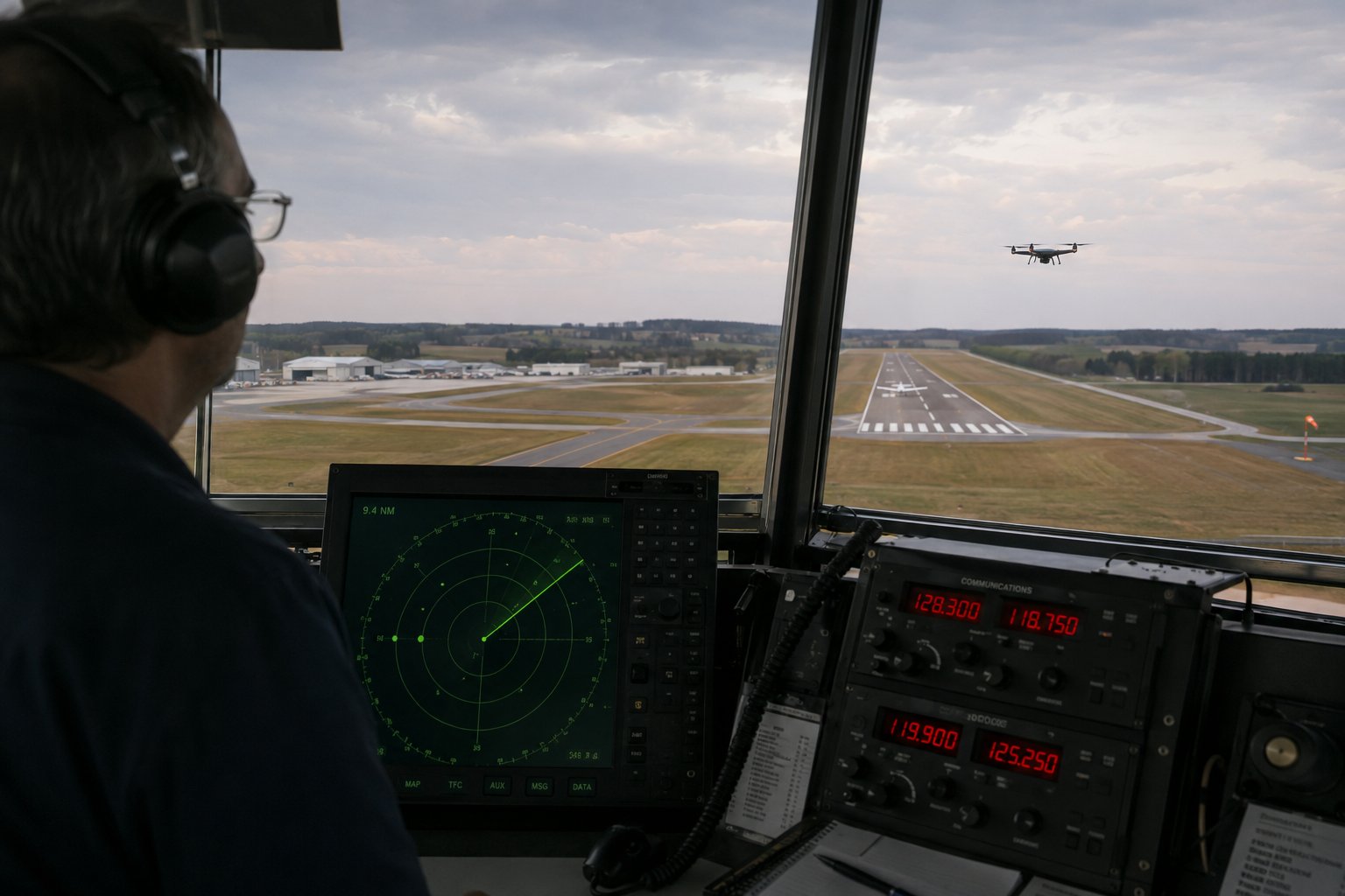
ATC controller view from the tower cab with radar display — a drone visible near the runway threshold
Example initial call: "Addison Ground, drone operator, Mustang Park, 1 mile northeast of the airport, requesting advisories for UAS operations." The tower will either acknowledge and provide advisories, ask you to standby, or advise you that operations are not possible at this time. Be concise, clear, and professional.
In an emergency: "Mayday, Mayday, Mayday. [Your position], drone operator, [nature of emergency]." The international distress call "Mayday" (from the French m'aider — help me) is used for life-threatening emergencies. For less urgent situations: "Pan-Pan, Pan-Pan, Pan-Pan" indicates urgency without immediate threat to life.
Full Communication Sequence Example
Here is a complete example of a professional drone operator communicating with a tower: Initial call: "Addison Tower, Drone Operator, one mile northeast of the field, 200 feet AGL, conducting a commercial survey operation, requesting advisories." Tower response: "Drone Operator, Addison Tower, roger, be advised we have a Cessna on a 3-mile final for Runway 15, advise when complete." Drone operator: "Addison Tower, Drone Operator, copy traffic, will advise." After completion: "Addison Tower, Drone Operator, survey complete, departing the area, good day." Tower: "Drone Operator, good day."
Note the professional elements: clear identification of who you're calling and who you are, specific position information, nature of operation, explicit request for advisories, acknowledgment of traffic information, and a proper close. This communication takes under 60 seconds, significantly improves safety coordination, and leaves a positive impression with ATC that may facilitate future operations in the area.
Communication During Emergencies
If your drone has an uncontrolled flyaway, is heading toward sensitive airspace, or is about to cause an emergency, immediate communication with ATC (if you have a radio) is appropriate: "Addison Tower, Drone Operator emergency, drone flyaway heading northeast, last position one mile northeast field, altitude unknown." This information allows ATC to warn manned aircraft, issue a PIREP (pilot report) about the hazard, and coordinate any necessary response. Even if the drone cannot be recovered, alerting ATC gives you documented evidence of good-faith emergency response.
Lesson 6 — Radio Frequencies and Airport Information
Aviation uses VHF (Very High Frequency) radios operating between 118.000 and 136.975 MHz. Key frequencies drone pilots should know:
- 121.5 MHz — International distress frequency. All aircraft and many ground stations monitor this frequency. In a drone emergency where you have a radio, transmitting on 121.5 MHz will reach the most listeners.
- CTAF (Common Traffic Advisory Frequency) — Used at non-towered airports for position announcements. Published on sectional charts and in the Airport/Facility Directory. Often shared with UNICOM (airport advisory service).
- Ground control frequencies — Typically in the 121.600–121.900 MHz range for taxiing and ground operations at towered airports.
- ATIS (Automatic Terminal Information Service) — Recorded loop of current weather and airport information updated hourly. Drones don't need to copy ATIS but knowing it exists and where to find the frequency is tested knowledge.
Airport frequencies are published on sectional charts and in airport data. The tower frequency is shown in a box near the airport symbol on sectional charts, along with ATIS and ground frequencies. Practice identifying these elements on sectional chart excerpts — the Part 107 exam uses them.
Sectional Chart Frequency Identification
Sectional charts display airport frequencies in the airport data block. The top frequency listed for towered airports is typically the ATIS frequency (if available), followed by the approach/departure control frequency (if applicable), tower frequency, and ground frequency. For non-towered airports, the CTAF/UNICOM frequency is shown. The format is consistent enough that with practice, you can quickly identify relevant frequencies for any airport shown on a sectional chart.
Tower frequencies typically fall in the 118-121.4 MHz range. Ground control is typically 121.6-121.9 MHz. ATIS is found in the 108-118 MHz range (VOR/ATIS band). Approach and departure control (TRACON) uses frequencies across the 118-136 MHz range. Emergency frequency 121.5 MHz is universally monitored. Knowing these general ranges helps you quickly tune the correct type of frequency when you need to make radio contact.
UNICOM and Advisory Services
UNICOM is a private aeronautical radio service found at many airports (towered and non-towered) that provides airport advisory services and fuel/service requests. At non-towered airports, UNICOM is often on the same frequency as the CTAF — pilots use it for both traffic advisories and to request services. A UNICOM operator (typically the FBO or airport manager) can provide wind information, runway in use, and traffic advisories, though they have no control authority over aircraft.
For drone operators planning regular operations at specific non-towered airports, establishing a relationship with the local FBO and UNICOM operator is valuable. They know the local traffic patterns, typical operating hours of different aircraft types, and can alert you to unusual activity (airshows, parachute operations, special events) that might not be captured in official NOTAMs or LAANC data. Local knowledge often supplements formal information sources effectively.