Night, Waiver & Advanced Operations
- Current night operations rules and lighting requirements
- Operations over people — categories and requirements
- Operations from moving vehicles
- Beyond Visual Line of Sight (BVLOS) waiver requirements
- The waiver application process and what makes a strong safety case
- Advanced commercial applications: mapping, inspection, agriculture
- Staying current — regulatory changes and continuing education
Lesson 1 — Night Operations
As of the April 2021 FAA Remote ID and Operations Over People final rule, night operations under Part 107 are permitted without a waiver, provided the drone is equipped with anti-collision lighting visible from at least 3 statute miles. This was a significant change from the original Part 107, which required a waiver for night operations.
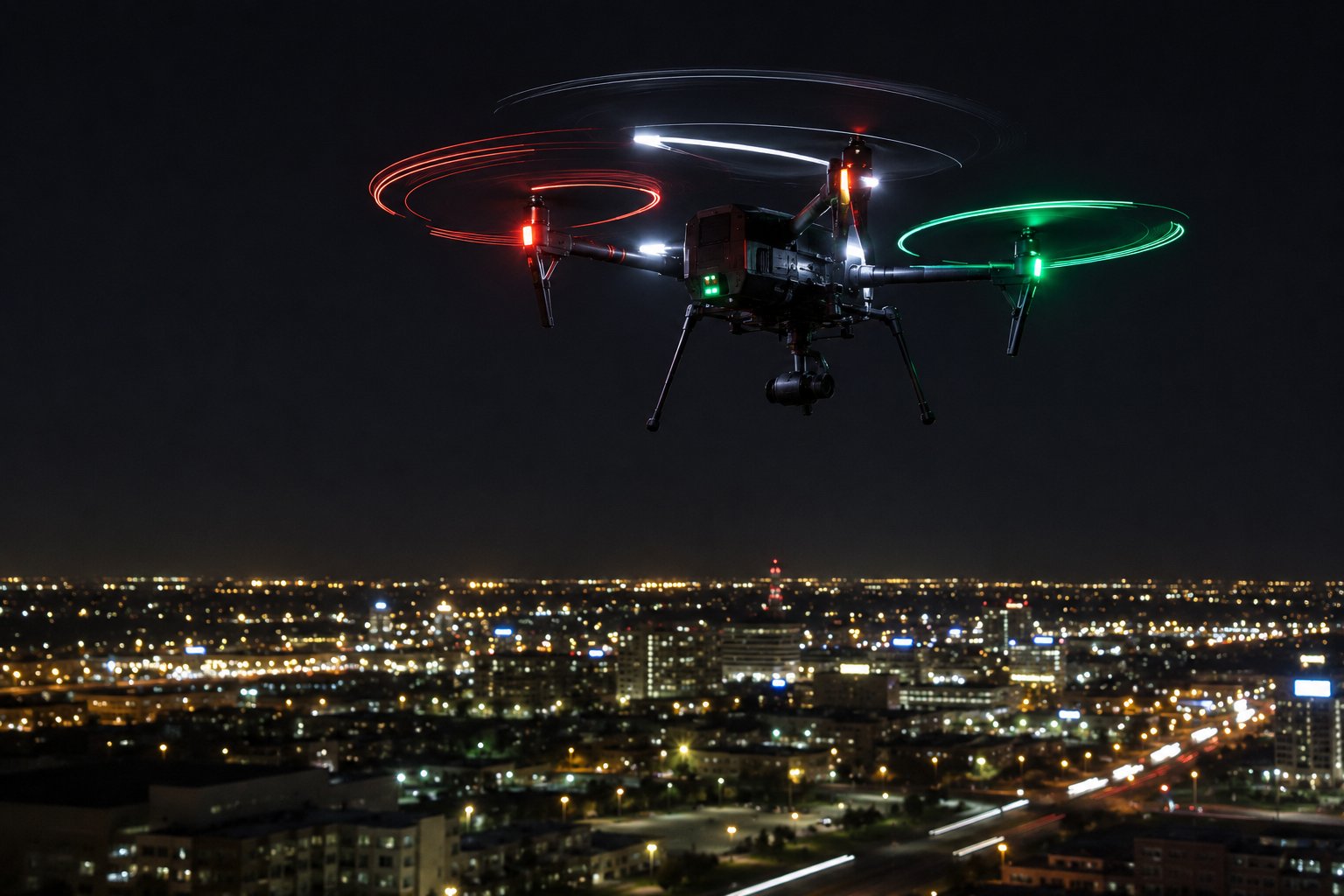
Commercial drone flying at night with anti-collision lighting — red port, green starboard, white strobe visible
Anti-collision lighting requirements: the light must be visible from 3 statute miles and must have a flash rate sufficient to indicate the drone is airborne. Most consumer drones — DJI Mavic series, Autel EVO series, and similar — come with lights that may or may not meet the 3-mile visibility requirement. Check your specific aircraft's documentation or add an aftermarket strobe light that meets the specification.
Night operations present unique challenges: maintaining visual line of sight is more difficult, depth perception is reduced, and other aircraft may be harder to spot. The drone's orientation lights (often red/green for port/starboard and white for tail — mirroring manned aircraft conventions) help maintain orientation awareness. Practice orienting your drone by its lights in low-light conditions before commercial night operations.
Civil twilight — 30 minutes before sunrise and 30 minutes after sunset — was previously the only non-waiver nighttime operation. Civil twilight still applies for operations without the required anti-collision lighting. With proper anti-collision lighting, you can operate during full darkness.
Night Operations Skill Development
Transitioning from daylight to night operations requires specific skill development. Depth perception is significantly reduced at night — judging distances to obstacles is much harder without shadows and familiar visual cues. Obstacle avoidance systems that work by vision often have reduced effectiveness in low light. The drone's orientation lights become your primary feedback for attitude and direction — practice until you can read orientation from lights reliably before conducting night commercial missions.
Develop a pre-night-flight site survey practice: walk the operating area before darkness falls to identify and memorize obstacle locations. Low walls, guy wires, fencing, and plant material that are obvious in daylight become nearly invisible at night. Mental mapping of the site during daylight significantly reduces collision risk during the actual night operation. Use temporary marking lights (glow sticks, small LED markers) on key obstacles or boundaries if the site permits.
Night Battery Management
Cold night temperatures affect battery performance significantly — the combination of cool air (which is actually better aerodynamically but worse for battery chemistry) and cold batteries requires more conservative planning than daytime operations. Pre-warm batteries to at least room temperature before night operations. Some operators use insulated battery pouches heated by hand warmers during pre-flight preparation to maintain optimal battery temperature through the first minutes of flight when cold temperatures would otherwise degrade performance most sharply.
Lesson 2 — Operations Over People
Flying over people who have not consented and are not directly participating in the operation was previously prohibited without a waiver. The 2021 rule created four categories of operations over people, each with different requirements:
| Category | Requirements | Typical Use |
|---|---|---|
| Category 1 | ≤0.55 lbs, no exposed rotating parts that could lacerate | Tiny consumer drones |
| Category 2 | Declared manufacturer compliance with injury severity limit, no waiver needed | Mid-size commercial drones with FAA declaration |
| Category 3 | Manufacturer compliance, additional operational restrictions (no sustained over-crowd flight) | Larger commercial operations |
| Category 4 | Airworthiness certificate, requires FAA-issued certificate | Package delivery, large commercial operations |
Most professional commercial drones fall under Category 2 or 3 requirements. Check your drone manufacturer's FAA compliance declarations — DJI, Autel, and Skydio have filed declarations for several models. Flying over moving vehicles in active roadways still requires either a waiver or that the vehicles and their occupants have consented and are participating in the operation.
Important restrictions regardless of category: you may not fly over a moving crowd (sporting event, concert, parade) without a waiver. Category 3 specifically prohibits sustained flight over open-air assemblies. When in doubt about whether an operation is compliant, the conservative approach is to avoid flying directly over non-participating people.
Determining Applicable Category for Your Drone
Determining which category applies to your specific drone requires checking the FAA's database of manufacturer declarations. DJI, Autel, Skydio, and other manufacturers have filed declarations for specific models. Not all models from a manufacturer are declared — check your specific model number and variant. The FAA maintains a current list of declared drones at faa.gov/uas/commercial_operators/operations_over_people.
If your drone's manufacturer has not filed a declaration, you cannot conduct Category 2 or 3 operations over people without a waiver, regardless of the drone's actual physical characteristics. The declaration process is the manufacturer's responsibility — you cannot self-certify your drone for operations over people. For operations requiring Category 2 or 3 capabilities with an undeclared drone, the options are: obtain a waiver, choose a declared aircraft, or modify operations to avoid flying over non-participating people.
Practical Site Control for Operations Over People
Even for Category 1 operations (under 0.55 lbs, minimal injury risk), maintaining awareness of people below or near the flight path is a core professional practice. Site control methods used in professional productions include: ground spotters who monitor the area and alert the RPIC when non-participating persons enter the operating area, temporary fencing or cones that create visual boundaries, crowd control announcements that keep bystanders at safe distances, and scheduling sensitive operations during off-peak hours when fewer people are present.
Lesson 3 — Operations From Moving Vehicles
14 CFR 107.25 permits drone operations from moving land or water vehicles in sparsely populated areas. The default prohibition on operations from moving vehicles exists because launching from a moving platform makes it very difficult to maintain precise control and orientation. The exception applies specifically to sparsely populated areas — not from vehicles in congested urban environments or on crowded public roads.
Operations from moving aircraft are separately addressed and generally require a waiver for commercial purposes. The specific waivable provision is 107.25(a)(2) — operations from a moving aircraft are not permitted without a waiver. This matters for deployments that involve launching drones from manned aircraft for survey or search-and-rescue applications.
Technical Challenges of Moving Platform Operations
Launching and landing from a moving vehicle creates several technical challenges beyond the regulatory requirements. GPS home point confusion: if the drone's home point is set at the vehicle's location at launch and the vehicle moves during flight, RTH will return the drone to the launch location — not the vehicle's current position. Some drones and apps support dynamic home point updating to follow a moving controller, but this requires specific configuration and testing before relying on it operationally.
Controller orientation confusion is another challenge: as the vehicle turns, the pilot's orientation relative to the drone changes. A drone flying "away" from the vehicle when the vehicle is heading north is flying in a different absolute direction when the vehicle turns east. Pilots accustomed to fixed-position operations must recalibrate their spatial orientation continuously when operating from a moving platform.
Maritime Operations
Operations from boats and ships combine the moving vehicle regulatory considerations with unique environmental challenges: constant vibration (affects gimbal stability and GPS compass calibration), salt spray (highly corrosive to electronics), wind over the water (often stronger than shore-based forecast suggests), and limited emergency landing options (land on the boat vs. ditch in the water). Maritime commercial drone operations — ship inspection, ocean survey, offshore facility monitoring — are a growing professional application requiring specific equipment and protocols designed for the marine environment.
Lesson 4 — Beyond Visual Line of Sight (BVLOS)
BVLOS — flying beyond where you can see the drone with unaided eyes — is one of the most commercially significant capabilities in the drone industry. Delivery, infrastructure inspection, precision agriculture, and emergency response all benefit enormously from BVLOS. However, BVLOS currently requires a waiver because the standard visual separation assurance is replaced by other methods that must be demonstrated to the FAA's satisfaction.
BVLOS waiver applications are among the most complex in drone regulation. A successful BVLOS safety case must address: how the operator will detect and avoid other aircraft without visual contact, what happens during communications failures, how the operation area will be secured to protect non-participating people, what detect-and-avoid technologies are installed, and what the operational boundaries and weather minimums are.
BVLOS corridors and blanket BVLOS approvals are gradually being issued by the FAA to operators who have established strong safety records and comprehensive safety management systems. The FAA's BEYOND program and subsequent operational trials have produced data that is informing the path toward more routine BVLOS operations. Regulatory evolution in this area is ongoing — check current FAA guidance for the latest BVLOS framework.
Detect-and-Avoid Technology
The core technical challenge of BVLOS operations is replacing the pilot's visual detect-and-avoid (DAA) capability — which exists by definition in VLOS — with equivalent electronic capability. Current DAA technologies used in BVLOS waiver applications include: ADS-B receivers (detect aircraft broadcasting ADS-B transponders), radar systems (detect non-broadcasting aircraft), FLIR cameras (detect heat signatures of aircraft), and cooperative ground radar networks. Each technology has coverage gaps — ADS-B doesn't detect aircraft without transponders, radar has resolution limits, FLIR requires line-of-sight.
The FAA's BVLOS ARC (Aviation Rulemaking Committee) has developed performance-based standards for DAA systems used in BVLOS operations. Operators seeking BVLOS waivers need to demonstrate that their DAA system meets performance standards appropriate for the operational environment — lower traffic environments (rural, sparsely populated areas) have different requirements than suburban or urban environments with more manned traffic.
BVLOS Industry Applications
The commercial applications driving BVLOS development are substantial. Package delivery at scale — the model pioneered by companies like Wing, Amazon Prime Air, and Zipline — requires BVLOS as a fundamental capability. Pipeline and powerline inspection covering hundreds of miles per day requires BVLOS. Wildlife monitoring over large wilderness areas, precision agriculture covering large farm parcels, and communications relay operations in emergency scenarios are all enabled by BVLOS. The economic value of mature BVLOS operations is estimated in the tens of billions of dollars annually — explaining the significant industry investment in DAA technology and regulatory development.
Lesson 5 — The Waiver Application Process
Waivers are submitted through FAA DroneZone. A complete waiver application includes: the specific rule you're requesting a waiver to (e.g., 107.29 for extended night operations, 107.31 for BVLOS, 107.39 for operations over people), a detailed description of the proposed operation, and a safety case explaining how you'll achieve equivalent safety without that rule.
The quality of a waiver safety case determines approval speed and likelihood. Generic descriptions ("I will fly safely") are rejected. Specific, quantified safety mitigations work: "The flight corridor will be established 200 feet from the nearest public road, visual observers will be positioned at 500-foot intervals with radio communication, and the aircraft will automatically return to home if link is lost for more than 5 seconds."
Processing times vary: simple waivers (night operations with proper lighting documentation) can be approved in days. BVLOS waivers with novel operations may take months. Start the waiver process 30-60 days before the intended operation for simple waivers, 90-120 days for complex ones.
Types of Waivers and Their Complexity
Not all waivers are equally complex. The spectrum from simpler to more complex: night operations with documented lighting (often approved quickly for operators with clean records) → operations over moving vehicles on sparsely populated roads → operations over people in controlled environments → operations from aircraft → BVLOS in rural low-traffic environments → BVLOS in populated areas with complex traffic. Understanding where your intended operation falls on this spectrum helps calibrate your application effort and timeline expectations.
Some waivers have become routine enough that the FAA has published guidance or templates. The FAA's night operations waiver was simplified significantly when the 2021 rule change made most night operations waiver-free — the remaining night waivers (for operations not covered by the standard rule) now have clearer expectations. The FAA's website publishes previously approved waivers (with operator information redacted) that serve as templates and benchmarks for new applications.
Operational Records as Waiver Evidence
Your historical operational record is evidence in waiver applications. An operator with 500+ flight hours, documented safety management system, no incidents, and previous successful waivers presents a fundamentally different safety profile than a new operator with 20 hours and no waiver history. Building your operational record — flight logs, safety procedures documentation, training records, and voluntary safety reporting — pays dividends when you eventually apply for more complex waivers. Start documenting from your first flight, not just when you anticipate needing waivers.
Lesson 6 — Advanced Commercial Applications
Mapping and photogrammetry: Drones equipped with cameras and GPS create georeferenced imagery that can be processed into 2D orthomosaic maps or 3D point cloud models. Applications include construction progress monitoring, land surveys, volumetric calculations for mining and aggregates, and archaeological surveys. Software like Pix4D, DroneDeploy, and Agisoft Metashape process the imagery. Flight planning for mapping missions uses automated grid patterns at consistent altitude and overlap percentages.
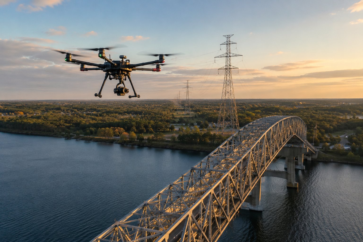
Professional hexacopter conducting bridge and power line inspection at golden hour
Infrastructure inspection: Power lines, cell towers, bridges, pipelines, and wind turbines benefit enormously from drone inspection. Close-proximity inspection (within a few feet of the structure) under the structure exception (400 feet above structure, within 400 feet horizontally) is already permitted under Part 107. This is one of the fastest-growing commercial drone applications because it dramatically reduces the cost and risk of sending humans into dangerous elevated environments.
Agricultural applications: Precision agriculture drones spray pesticides and fertilizers, analyze crop health through multispectral imaging, and map drainage patterns and soil variability. Agricultural spraying drones require separate State-level pesticide applicator licensing in addition to Part 107 certification. Multispectral and thermal imaging sensors are increasingly common on professional agricultural mapping platforms.
Real Estate and Construction Visualization
Real estate aerial photography is one of the most accessible entry points for commercial drone work — relatively simple operations, clear client demand, and well-understood workflows. The professional differentiators in this market are not just image quality (most modern drones produce comparable results) but consistency, reliability, turnaround time, and understanding of what makes compelling real estate imagery. Properties photograph best in the "golden hour" (first hour after sunrise, last hour before sunset) when warm light and long shadows reveal architectural detail and landscaping.
Construction documentation — systematic aerial surveys of project sites at regular intervals showing progress — is a high-value, recurring revenue application. Construction clients pay for the data (orthomosaic maps, 3D models, volumetric calculations) rather than just images. This requires drone pilots who understand photogrammetry workflows, can produce consistent, georeferenced outputs, and can deliver data in formats compatible with construction project management software like Autodesk BIM 360 and Procore.
Public Safety and Emergency Management
Law enforcement, fire, and emergency management agencies increasingly operate drone programs under specialized COAs (Certificates of Authorization) or Part 107. Public safety drone applications include: aerial surveillance during tactical operations, search and rescue over terrain or water, wildfire monitoring and spotting, disaster damage assessment, and crowd monitoring at major events. Public safety drone pilots often operate under more permissive authorizations than commercial operators — but require additional training in operational security, privacy law, and coordination with incident command structures.
Volunteer drone operators can contribute to search and rescue through organizations like the Drones as First Responders (DFR) programs and the Civil Air Patrol UAS program. These programs provide training, equipment access, and operational frameworks that allow qualified volunteer drone pilots to assist in emergency operations under proper authorization. For drone pilots interested in contributing to public safety, these volunteer programs provide both meaningful contribution and valuable operational experience.
Lesson 7 — Staying Current
Drone regulation is one of the fastest-evolving areas in federal aviation law. The original Part 107 (2016) has already been significantly amended with the Remote ID rule (2021), the operations over people rule (2021), and ongoing rulemaking for BVLOS and advanced air mobility. Regulatory currency is not just about completing the required recurrent training — it requires active monitoring of FAA rulemaking and industry developments.
Resources for staying current: the FAA's UAS website (faa.gov/uas), the FAA DroneZone for operational updates, the Commercial Drone Alliance for industry advocacy and updates, and platforms like AUVSI (Association for Unmanned Vehicle Systems International) for professional development. Set up Google Alerts for "FAA Part 107" and "FAA UAS" to receive automatic notification of news coverage of regulatory changes.
The 24-month recurrent training requirement at faasafety.gov covers regulatory updates and should be completed on schedule. But professional operators go further — they understand the regulatory landscape well enough to anticipate changes, engage in the comment process on proposed rules, and build operations that can adapt as the regulatory framework evolves.
FAA Rulemaking Process and How to Participate
The FAA regulatory process — notice-and-comment rulemaking under the Administrative Procedure Act — provides public participation opportunities that directly affect drone regulation. When the FAA proposes a new rule, it publishes a Notice of Proposed Rulemaking (NPRM) in the Federal Register and opens a comment period (typically 60-90 days) during which anyone can submit comments. These comments genuinely influence the final rule — the FAA must respond to substantive comments and frequently modifies proposed rules based on industry and public input.
The drone industry's active engagement in the Part 107 development process produced a more workable regulatory framework than the FAA's initial proposals would have created. Individual operators who submit thoughtful, experience-based comments on proposed UAS rules contribute to better outcomes for the entire industry. Sign up for FAA NPRM notifications at faa.gov and consider commenting on rulemakings that affect your operations.
Building Professional Credentials Beyond Part 107
Part 107 is the entry credential — professional advancement in commercial drone work often requires additional specialization. Photogrammetry software certification (Pix4D, DroneDeploy, Agisoft), thermographic imaging certification for roof inspections, FAA Part 107 advanced waivers for specific operation types, and industry-specific certifications (AUVSI's SUAS Certificate of Training) build a professional profile that commands higher rates and attracts more sophisticated clients. The drone industry is rapidly professionalizing — operators who invest in specialization ahead of the market establish durable competitive advantages.
Professional organizations — AUVSI (Association for Unmanned Vehicle Systems International), the Drone Service Providers Alliance, and the Commercial Drone Alliance — provide networking, professional development, and industry advocacy that solo operators benefit from. The drone industry is small enough that professional relationships and reputation matter significantly. Building your professional network from early in your career — attending AUVSI XPONENTIAL, connecting with local drone operator communities, and participating in online professional forums — pays long-term dividends.