Aviation Weather — Reading the Sky Before You Leave the Ground
Weather is the most complex, most tested, and most consequential topic in private pilot training. More GA accidents involve weather than any other single factor. This module teaches you how the atmosphere works, how to decode every weather product you'll use, and how to make sound go/no-go decisions using real data. See our full weather for pilots guide →
- Describe atmospheric stability and explain how it determines weather type
- Explain the characteristics of cold and warm fronts and their associated hazards
- Decode a complete METAR and TAF with all common groups
- Distinguish between AIRMETs and SIGMETs and identify when each applies to VFR flight
- Describe structural icing conditions and explain why VFR aircraft must avoid them
- Explain thunderstorm formation, stages, and mandatory avoidance procedures
- Apply a structured weather briefing and go/no-go framework to a real scenario
Lesson 1 — The Atmosphere and Stability
All weather occurs in the troposphere — the lowest layer of the atmosphere, extending from the surface to approximately 36,000 ft at mid-latitudes. Temperature normally decreases with altitude at the standard lapse rate of approximately 2°C per 1,000 ft (3.5°F/1,000 ft). This normal temperature decrease is what allows weather to develop: as air rises, it cools, and eventually moisture condenses into clouds.
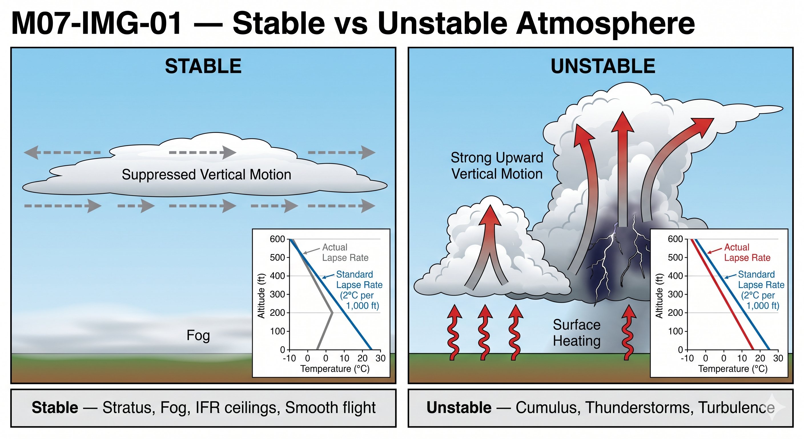
Atmospheric stability — the key to predicting weather type
Stability describes how the atmosphere responds when a parcel of air is displaced upward. This single concept predicts whether you'll see smooth stratus layers or towering cumulonimbus — whether your flight will be smooth or turbulent.
Unstable atmosphere: When the actual temperature decreases faster than the standard lapse rate, rising air remains warmer than the surrounding environment and continues to rise on its own. This self-sustaining ascent builds cumulus clouds — the puffy, vertical clouds. In extreme instability, cumulus towers into cumulonimbus. Unstable air means convective development: turbulence, showers, and potentially thunderstorms. The atmosphere is most unstable in summer afternoons when surface heating is greatest.
Stable atmosphere: When the actual temperature decreases more slowly than the standard lapse rate (or increases with altitude — an inversion), rising air quickly becomes cooler than its surroundings and sinks back. Stability suppresses vertical motion and keeps weather in horizontal layers: stratus, fog, haze, and widespread low ceilings. Stable conditions produce smooth flight but poor visibility and IFR ceilings that don't burn off quickly.
Temperature inversions
A temperature inversion occurs when temperature increases with altitude — a complete reversal of the normal lapse rate. Inversions create an extremely stable layer that acts as a lid on the atmosphere below it. Smoke, haze, fog, and pollutants become trapped beneath the inversion layer, often reducing visibility to IFR conditions at the surface while skies above the inversion are clear and smooth. Radiation inversions (the most common type) form overnight when the Earth's surface cools rapidly under clear skies. They typically dissipate 2–3 hours after sunrise as surface heating breaks them down.
Inversions also cause a phenomenon called low-level wind shear — a sudden change in wind speed or direction between the stable surface layer and the air above the inversion. Aircraft on approach or departure can encounter abrupt airspeed changes crossing through an inversion layer.
The standard atmosphere — what "standard" means and why it matters
When aircraft performance charts are published, they use the International Standard Atmosphere (ISA) as the reference: sea-level pressure of 29.92 inHg, sea-level temperature of 15°C (59°F), and a lapse rate of 2°C per 1,000 feet. Every performance chart in your POH — takeoff distance, climb rate, cruise speed — is based on ISA conditions. Real-world conditions deviate from ISA constantly, which is why you must always correct performance charts for actual conditions.
The key rule: hot, high, and humid = degraded performance. Every degree above ISA temperature reduces engine power, reduces propeller efficiency, and reduces lift production. Every 1,000 feet of density altitude above ISA pressure altitude reduces available power by approximately 3%. At high-elevation airports on hot days, performance can be dramatically worse than the chart base values suggest.
Stability and convection — why clouds form where they do
Atmospheric stability determines whether a parcel of air will rise on its own (unstable) or resist vertical motion (stable). When a parcel of air rises, it cools at the dry adiabatic lapse rate of about 3°C/1,000 ft. If the surrounding air is cooler than the rising parcel at any altitude, the parcel is warmer and lighter — it keeps rising. This is instability. If the surrounding air is warmer than the rising parcel, the parcel is denser than its environment and sinks back — this is stability.
Temperature inversions — why they matter for pilots
A temperature inversion occurs when temperature increases with altitude rather than decreasing — the opposite of the normal lapse rate. This creates an extremely stable layer that traps pollution, smoke, and moisture below it. For pilots, inversions matter for several reasons:
- Reduced visibility below the inversion: Trapped haze and smoke can cut surface visibility to 3–5 miles even under clear skies above.
- Smooth air above, turbulent air below: The inversion layer often marks the transition from turbulent, unstable air below to smooth, stable air above. Climbing through the inversion can provide relief from low-level turbulence.
- Fog formation: Radiation fog (common overnight in valleys) forms and persists under inversions because the stable air prevents mixing that would dissipate the fog.
- Trapped weather: Thunderstorm outflows and frontal weather can be capped and intensified by an inversion above. A storm that seems small at the surface may have tremendous energy stored beneath an inversion.
Lesson 2 — Frontal Systems and Their Weather
A front is the boundary between two air masses with different temperature, moisture, and density characteristics. Most significant weather in the continental US occurs along or near fronts. Understanding what type of front you're dealing with lets you predict what weather to expect — and from how far away.
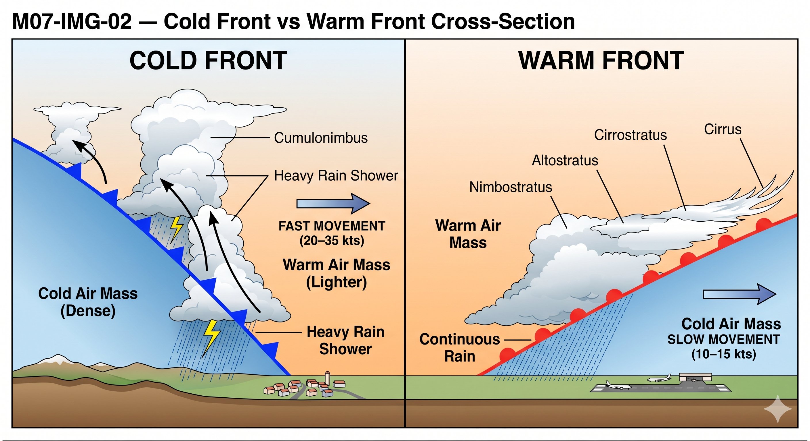
Cold fronts — fast, violent, narrow
A cold front is the leading edge of a cold air mass actively undercutting and displacing warmer air. Cold fronts move faster than warm fronts — typically 20–35 knots — and produce weather concentrated in a narrow band extending only 50–100 miles either side of the surface front. The atmosphere is violently unstable along a cold front: cumulonimbus, thunderstorms, squall lines, heavy precipitation, and gusty winds are all possible.
The good news about cold fronts: they pass quickly. A cold front moving at 30 knots will clear a given location in 2–6 hours. After cold front passage, conditions improve rapidly — temperature drops, dew point drops, winds shift (veer — clockwise in the Northern Hemisphere), visibility improves dramatically, and ceilings rise. The cold, dry post-frontal air often produces the clearest, smoothest flying of the week.
The bad news: prefrontal weather can extend 100–200 miles ahead of the surface front position as warm moist air is destabilized. Don't assume that because you're "ahead of the front" you're in safe air.
Warm fronts — slow, broad, insidious
A warm front is the leading edge of warm air gradually overriding retreating cold air. Because warm air is less dense, it can't plow through cold air the way a cold front does — instead it rides up over the cold air at a very shallow angle, creating a cloud and precipitation shield that extends hundreds of miles ahead of the surface front.
The sequence of clouds as a warm front approaches from hundreds of miles away: cirrus (high, wispy ice crystals — the first warning sign, up to 1,000 miles ahead) → cirrostratus (thin veil creating halos around sun and moon) → altostratus (gray overcast, sun visible as if through frosted glass) → nimbostratus (dark, low, thick layer with continuous rain). By the time you see low ceilings and rain, the surface front may still be 200–300 miles away.
The warm front trap: VFR pilots frequently underestimate warm fronts because deterioration is gradual. A pilot departing into marginal conditions "ahead of" a warm front may find conditions worsening steadily until they are trapped in IFR with no clear escape route ahead or behind. When a warm front is on the forecast for your destination, check ceilings 200 miles ahead of the surface front position — that's where you'll be flying.
Cold fronts — rapid deterioration and what to expect
A cold front is the boundary where advancing cold air undercuts and lifts warmer air ahead of it. Cold fronts move faster than warm fronts (typically 25–30 knots) and produce weather that is intense but shorter in duration. The key cold front indicators:
- Ahead of the front: Warm, humid air, often southerly winds, decreasing pressure, cirrus clouds appearing first, then altocumulus and altostratus as the front approaches.
- At the front: Rapid wind shift (usually from south/southwest to northwest), pressure rises sharply, temperature drops quickly. Cumulonimbus development along the frontal line — squall lines can extend 100+ miles ahead of a fast-moving cold front.
- Behind the front: Clearing, colder temperatures, northwest winds, improving visibility, scattered cumulus from surface heating in the fresh air mass.
The cold front passage itself is typically brief — 1–3 hours of active weather — but the squall line ahead of it can be the most dangerous part. Pre-frontal squall lines can develop 50–200 miles ahead of the surface front where the two air masses interact aloft. Always check for squall line development when a fast-moving cold front is approaching.
Warm fronts — long-duration deterioration and IFR trap
A warm front is the boundary where warmer air advances and overrides the cooler air it's replacing. Warm fronts move slowly (10–15 knots) and produce gradual weather deterioration over a very large area — sometimes 500–1,000 miles ahead of the surface front. This is the classic instrument flight trap for VFR pilots: the weather doesn't hit you suddenly; it sneaks up on you over hundreds of miles until you're in IMC without realizing how you got there.
The warm front sequence (approaching from ahead): cirrus at 400+ miles, then cirrostratus (the halo around sun/moon), altostratus (sun or moon visible but diffuse), nimbostratus (overcast, continuous rain/drizzle, IFR conditions), stratus at the surface. By the time you see low stratus and continuous precipitation, the surface front is still 200–300 miles away — and conditions will continue to deteriorate until passage.
The VFR pilot rule for warm fronts: When you see virga (precipitation that evaporates before reaching the ground) transitioning to light rain, or when visibility starts dropping slowly with lowering clouds over a 2–3 hour period — you're in a warm front deterioration pattern. Land immediately. The conditions will not improve on their own for many hours.
Stationary fronts and occluded fronts
A stationary front is simply a cold or warm front that has stopped moving. It persists in the same area for days, producing continuous precipitation, persistent IFR conditions, and fog. Weather forecasting becomes difficult because the front can begin moving again unpredictably.
An occluded front forms when a faster-moving cold front catches a warm front — the cold air undercuts both air masses and lifts the warm sector off the surface entirely. Occlusions produce complex weather with characteristics of both cold and warm fronts — heavy precipitation, embedded thunderstorms possible, and prolonged IFR conditions.
Lesson 3 — Clouds and What They Tell You
Clouds are the atmosphere's weather report — visible evidence of what the air is doing right now. Every cloud type tells you something specific about the conditions around it. Learning to read clouds is a skill that supplements all your weather products and works anywhere in the world, with no technology required.
Cloud classification by altitude and form
High clouds (above 20,000 ft): Composed primarily of ice crystals. Cirrus are thin, wispy streaks — beautiful to look at, but often the first indicator of an approaching warm front. Cirrostratus forms a thin veil across the sky that creates halos around the sun and moon — a reliable warm front sign. High clouds alone rarely ground VFR flights, but they demand your attention as weather scouts.
Middle clouds (6,500–20,000 ft): Altostratus is the gray uniform overcast that makes the sun look like it's behind frosted glass — rain is typically 12–24 hours away under a thickening altostratus. Altocumulus forms in waves or patches; when altocumulus castellanus (towers developing from the altocumulus layer) appears in the morning, afternoon thunderstorms are highly likely — this is one of the most reliable convective forecasting signs.
Low clouds (surface to 6,500 ft): Stratus is the flat, featureless gray layer that creates IFR conditions. It forms in stable air and can persist for days. Stratocumulus (lumpy rolls of gray cloud) is the most common cloud type — it creates overcast but often with higher ceilings than stratus. Nimbostratus is the dark, low, continuous-rain cloud — true IFR with poor visibility underneath.
Clouds with vertical development: Cumulus clouds range from harmless "fair weather cumulus" (flat bases, limited vertical extent) to threatening towering cumulus (TCU) to full cumulonimbus (CB — the thunderstorm cloud). The critical sign to watch: rate of vertical development. A cumulus that was 2,000 ft tall an hour ago and is now 8,000 ft is developing rapidly — give it room and time to develop fully before deciding whether to route around it.
Fog types pilots encounter: Radiation fog forms overnight under clear skies and calm winds as the ground cools. Thick by dawn, it typically burns off 1–3 hours after sunrise. Advection fog forms when warm moist air moves over a cooler surface — common along coastlines and can be extremely persistent, not burning off with daytime heating. Upslope fog forms as moist air is forced up terrain — common in the Rockies and Appalachians. Steam fog forms when cold air moves over warmer water — looks like steam rising from a lake or river.
Reading clouds for weather intelligence — the four families
Clouds fall into four families based on altitude and formation mechanism. Understanding the family tells you immediately what kind of weather is likely:
High clouds (above 20,000 ft): Cirrus, cirrocumulus, cirrostratus. Composed of ice crystals. Cirrus ("mare's tails") alone means nothing immediate, but a thickening cirrus layer followed by cirrostratus (producing halos around sun or moon) is the classic advance indicator of a warm front 12–24 hours away.
Middle clouds (6,500–20,000 ft): Altocumulus, altostratus. Altocumulus in a "mackerel sky" pattern (broken white puffs) indicates convective instability at altitude — often the precursor to afternoon thunderstorm development. Altostratus (gray, uniform overcast) means precipitation is likely within 6–12 hours as the warm front approaches.
Low clouds (surface to 6,500 ft): Stratus, stratocumulus, nimbostratus. Stratus is the fog that won't lift — gray, featureless, uniform ceiling. Nimbostratus produces steady rain or snow and persists for hours. Stratocumulus (layered, lumpy — common in the afternoon after morning fog burns off) is generally benign but can hide cumulonimbus buildups embedded within.
Vertically developed clouds: Cumulus, cumulonimbus. These are formed by convection. Cumulus alone (fair-weather cumulus) means instability but nothing hazardous — if the tops are flat and low, they won't build further. Towering cumulus (tcu) means active vertical development — watch for cumulonimbus. Cumulonimbus (cb) means thunderstorm — avoid by at least 20 miles in VFR conditions.
Fog types — why fog matters so much for landing
Fog is essentially a cloud at the surface — water droplets suspended in air at ground level. It can reduce visibility to near zero in minutes. The most common types that affect pilots:
Radiation fog: Forms overnight when the ground radiates heat, chilling the air layer immediately above it. Common in valleys on calm, clear nights. Usually "burns off" by mid-morning as the sun warms the surface. If your destination reports radiation fog at 6 AM, plan arrival after 10 AM or have a fog-free alternate.
Advection fog: Forms when moist air moves over a cooler surface. Common along coastlines (warm moist air off the ocean moves inland over cooler land). Unlike radiation fog, advection fog doesn't burn off during the day — it requires wind shift or air mass change to dissipate. San Francisco Bay Area coastal fog is a classic example.
Upslope fog: Moist air forced up terrain slopes cools to the dew point. Common on the windward side of mountain ranges, especially in spring. Can form rapidly as wind brings moist air against rising terrain.
Lesson 4 — Decoding METARs
The METAR (Meteorological Terminal Air Report) is the standard format for reporting current weather conditions at airports. Issued hourly (and as Special METARs when conditions change significantly), METARs are the most current and reliable source of actual conditions at a specific location. Every pilot must be able to decode one from memory.
Complete METAR decode — every group explained
| Group | Value | Meaning |
|---|---|---|
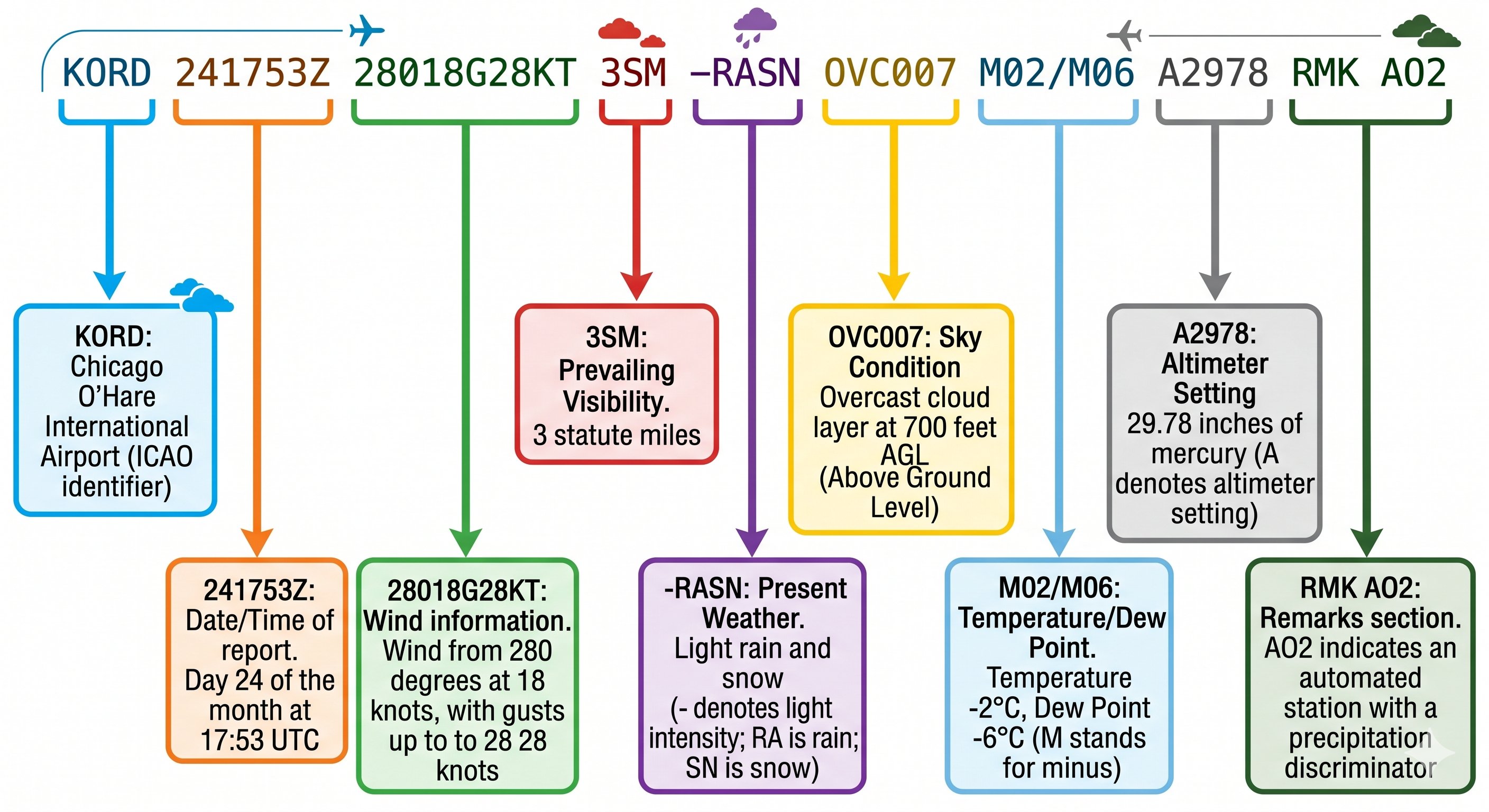
| Station ID | KORD | Chicago O'Hare International Airport. "K" prefix = continental US. Canada uses "C", international uses 4-letter ICAO identifier. |
| Date/Time | 241753Z | Day 24 of the month, time 1753 UTC (Zulu). Always UTC — convert to local time using your time zone offset. |
| Wind | 28018G28KT | Wind FROM 280° at 18 knots, gusting to 28 knots. "VRB" = variable direction. Calm = 00000KT. Always magnetic direction. |
| Visibility | 3SM | 3 statute miles. MVFR threshold is 3–5 SM. IFR: 1–3 SM. LIFR: less than 1 SM. |
| Weather | -RASN | Light (−) rain (RA) and snow (SN) simultaneously. No prefix = moderate. (+) = heavy. "FZ" prefix = freezing. "TS" = thunderstorm. |
| Sky condition | OVC007 | Overcast at 700 ft AGL (numbers in hundreds of feet). OVC = 8/8 coverage = solid ceiling. BKN (5–7/8) also constitutes a ceiling. |
| Temp/Dew point | M02/M06 | Temperature −2°C, dew point −6°C. "M" prefix = minus (below zero). Spread = 4°C. Wide spread = low fog risk. Close spread = high fog risk. |
| Altimeter | A2978 | 29.78 inHg. Set this in the Kollsman window. Below 29.92 = lower than standard pressure. Note: international stations use QNH in hPa/mb. |
| Remarks | RMK AO2... | AO2 = automated station with precipitation discriminator. RAB45 = rain began at :45 past the hour. SLP071 = sea level pressure 1007.1 mb. |
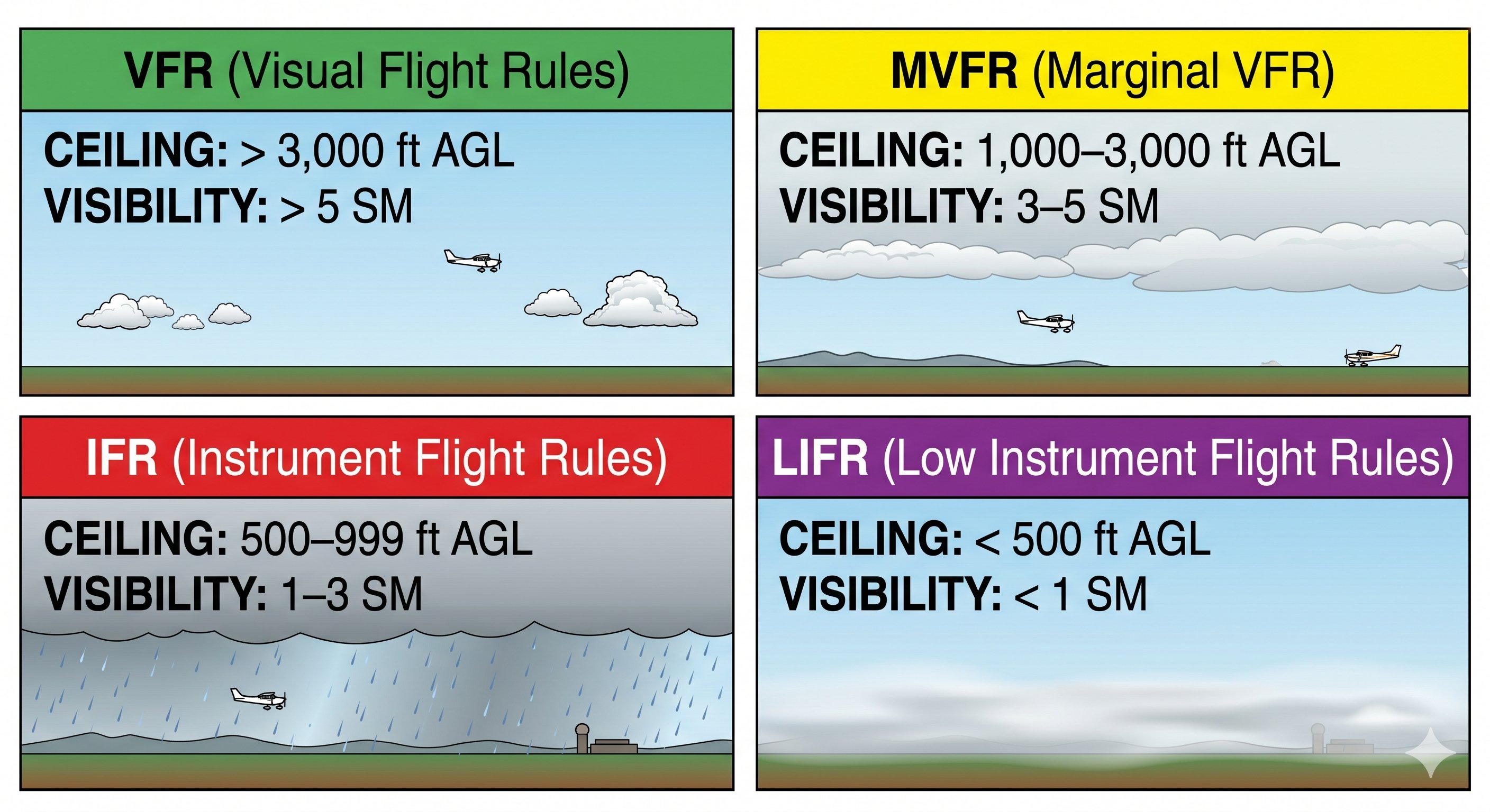
VFR flight categories
| Category | Ceiling | Visibility | Implication |
|---|---|---|---|
| VFR | Above 3,000 ft AGL | Greater than 5 SM | Normal VFR flight |
| MVFR | 1,000–3,000 ft AGL | 3–5 SM | Marginal — caution, above legal VFR minimums but low |
| IFR | 500–999 ft AGL | 1–3 SM | Below VFR minimums — instrument conditions |
| LIFR | Below 500 ft AGL | Less than 1 SM | Low IFR — severe restriction |
Common METAR weather codes to memorize: RA=rain, SN=snow, FG=fog (visibility ≤ 5/8 SM), BR=mist (5/8–6 SM), HZ=haze, TS=thunderstorm, GR=hail, FZRA=freezing rain, FZDZ=freezing drizzle, SQ=squall, FC=funnel cloud/tornado. Intensity prefix: (−)=light, none=moderate, (+)=heavy.
Decoding every field of a METAR — complete worked example
Let's decode a complete METAR in sequence. Every field has a meaning and every pilot must be able to read this in seconds:
- METAR — Report type. SPECI = special (unscheduled due to significant change)
- KSLC — Station identifier. K prefix = continental US. KSLC = Salt Lake City International
- 241753Z — Day and time. 24th day of the month, 1753 Zulu (UTC)
- 27018G28KT — Wind. 270° at 18 knots, gusting to 28 knots. If calm: 00000KT. Variable: VRB05KT
- 10SM — Visibility in statute miles. 10SM = 10 statute miles or greater. M = less than (M1/4SM = less than 1/4 mile)
- FEW045 — Cloud layer. FEW = 1–2 oktas coverage at 4,500 ft AGL. SCT = 3–4 oktas at 8,000. BKN = 5–7 oktas at 12,000 ft
- 22/08 — Temperature/dew point in Celsius. 22°C temperature, 8°C dew point. Spread of 14° = low fog risk. M = minus (M05 = −5°C)
- A2985 — Altimeter setting. 29.85 inHg. Set this in your Kollsman window
- RMK AO2 — Remarks. AO2 = automated station with precipitation discriminator
- SLP112 — Sea level pressure. 1011.2 mb (prepend 9 or 10 — whichever makes sense for the value)
Determining ceiling from a METAR
The ceiling is the lowest broken (BKN) or overcast (OVC) layer. FEW and SCT are not ceilings. In the METAR above: FEW045, SCT080, BKN120 — the ceiling is 12,000 ft (the BKN layer). VFR requires ceilings above 1,000 ft and visibility above 3 SM for the destination airport. A BKN030 in a METAR means ceiling is 3,000 ft — VFR legal, but marginal. A BKN006 means 600 ft ceiling — well below VFR minimums.
Special conditions: VV (vertical visibility) instead of cloud layers means the sky is obscured — typically by fog, smoke, or precipitation. VV010 means vertical visibility of 1,000 feet into the obscuring phenomenon — effectively a 1,000 ft ceiling in instrument terms.
Lesson 5 — TAFs, PIREPs, and Winds Aloft
Terminal Aerodrome Forecast (TAF)
A TAF provides a 24–30 hour forecast for conditions at a specific airport in METAR-like format. TAFs are issued four times daily (0000, 0600, 1200, 1800 UTC) and are the primary forecast tool for planning individual flights.
2418/2424 27015KT 10SM FEW040 SCT080
FM2500 32020G35KT 5SM -SN OVC015
TEMPO 2502/2506 2SM SN OVC008
PROB30 2508/2512 FZRA
| TAF Group | Meaning |
|---|---|
| 2418/2424 | Valid period: day 24 from 1800Z to day 24 at 2400Z. The forecast applies during this window. |
| FM2500 | FROM day 25 at 0000Z — a permanent change replacing everything that came before it. When you see FM, the previous conditions are entirely replaced. |
| TEMPO | Temporary — conditions expected to last less than one hour at a time, occurring during less than half the period. Brief fluctuations, not sustained. |
| PROB30 | 30% probability of stated conditions. Do not plan on PROB30 occurring — but note it as possible. PROB40 is more significant but still uncertain. |
PIREPs — Pilot Reports
PIREPs (Pilot Reports) are the most valuable real-time weather intelligence available. A pilot who just flew through your planned route 30 minutes ago can tell you exactly what icing level they encountered, where turbulence was, what the cloud tops were, and what visibility was like — information no forecast model can match.
PIREPs are filed by pilots via radio to ATC or FSS and collected in the weather system. Routine PIREPs (UA) report normal conditions; urgent PIREPs (UUA) report hazardous conditions and are broadcast immediately. Always check recent PIREPs before flights where turbulence, icing, or convective activity is possible. A single PIREP reporting severe icing at your planned altitude is worth more than any model forecast for that flight.
Winds aloft forecast (FB Winds)
Winds aloft forecasts give predicted wind direction, speed, and temperature at various altitudes (3,000 through 53,000 ft) at specific reporting points. Key rules for reading winds aloft:
- Direction is true — not magnetic. Apply variation to convert to magnetic heading for navigation use.
- Calm or light and variable is coded as 9900 in the raw data.
- Speeds above 99 kts are coded by adding 50 to the direction and subtracting 100 from the speed (e.g., "7545" = direction 250°, speed 145 kts).
- No winds reported below 1,500 ft AGL or within 2,500 ft of the station elevation — surface conditions are too variable.
- Temperature is important for icing awareness — identify the altitude where temperature is near 0°C and avoid that layer in visible moisture.
Reading TAF change groups — the most tested TAF skill
TAFs use specific change group indicators that modify conditions for defined periods. Missing or misreading these turns a clear-day forecast into an "I didn't know it was going to be IFR" situation:
- FM (From): Complete change at the specified time. All previous conditions are replaced. FM1800 means from 1800Z onward, all new conditions apply. The cleanest change group — no ambiguity.
- TEMPO (Temporary): Temporary fluctuations expected to last less than an hour at a time and occupy less than half of the forecast period. Conditions will return to the base forecast. TEMPO is often used for thunderstorms, brief wind shifts, or transient visibility reductions.
- PROB30 / PROB40: Probability of conditions occurring. PROB30 means 30% chance, PROB40 means 40% chance. If you see PROB30 TSRA (30% probability of thunderstorms with rain), it's not certain — but it's worth having an alternate plan.
- BECMG (Becoming): A gradual change occurring over a 2-hour window. BECMG 1416 means conditions gradually changing between 1400 and 1600Z. Unlike FM which is instant, BECMG is a slow transition.
PIREPs — the only real-time weather information from inside the cloud
A PIREP (Pilot Report) is a weather observation made by a pilot in flight and reported to ATC or Flight Service. METARs tell you what the weather is like on the ground. TAFs tell you what it's forecast to be. PIREPs tell you what it's actually like in the airspace right now — the only source for in-flight turbulence, icing, and cloud tops information.
A PIREP format: UA (routine) or UUA (urgent) /OV (location) /TM (time) /FL (flight level) /TP (aircraft type) /SK (sky conditions) /WX (weather) /TA (temperature) /WV (wind) /TB (turbulence) /IC (icing) /RM (remarks).
How to read a PIREP: UA /OV SLC045025 /TM 1630 /FL085 /TP C172 /SK OVC 070-090 /TB LGT-MOD /IC LGT RIME /RM TOPS AT 090 — This says: routine PIREP, location 025° radial from SLC VOR at 25 nm, time 1630Z, altitude 8,500 ft, Cessna 172, overcast layer between 7,000 and 9,000 ft, light to moderate turbulence, light rime icing, cloud tops at 9,000 ft. This is invaluable — you know before takeoff that the clouds top out at 9,000 ft and there's rime icing inside them.
Winds aloft — planning cruise altitude for speed and efficiency
The Winds Aloft forecast (FB winds) gives wind direction, speed, and temperature at multiple altitudes for forecast points across the US. Format: DDSSTT — direction (2 digits), speed (2 digits), temperature (2 digits with sign). Example: 2735+08 = 270° at 35 knots, +8°C. Exception: winds of 99 knots or more use light winds code (9900 = calm or not significant).
Use winds aloft to choose your cruise altitude: if 6,000 ft shows a 20-knot headwind and 8,000 ft shows a 10-knot headwind for a westbound flight, climbing to 8,000 saves fuel and time. If 10,000 ft shows a 40-knot tailwind for an eastbound flight, climbing there saves significant time over the entire route. Always check at least three altitudes above and below your planned cruise — the optimal altitude is not always obvious from ground level.
Lesson 6 — AIRMETs and SIGMETs
Aviation weather advisories are issued by the Aviation Weather Center (AWC) to alert pilots to conditions that may be hazardous. Knowing the difference between AIRMET types and SIGMETs — and which ones require immediate action for VFR pilots — is a critical written test topic and a real-world safety skill.
AIRMETs — Airmen's Meteorological Information
AIRMETs are issued for conditions that may be hazardous to light aircraft and VFR operations, covering broad areas. They are updated every 6 hours with amendments as needed. There are three types, each with a distinct letter designator:
| AIRMET | Designator | Covers | VFR Impact |
|---|---|---|---|
| Sierra | S | IFR conditions (ceilings below 1,000 ft and/or visibility below 3 SM) affecting 3,000+ sq miles. Also mountain obscuration. | High — you may fly into IMC. Active Sierra on your route is a serious warning to check conditions carefully or not go. |
| Tango | T | Moderate turbulence, sustained surface winds over 30 kts, low-level wind shear (LLWS). | Medium — expect a bumpy ride. May be manageable at different altitude. LLWS on approach is dangerous. |
| Zulu | Z | Moderate icing and freezing level information. | Medium-High — fly in visible moisture at the icing level and you will accumulate ice. VFR aircraft without anti-ice: avoid. |
SIGMETs — Significant Meteorological Information
SIGMETs cover conditions hazardous to all aircraft — not just light aircraft. They are more serious than AIRMETs. Non-convective SIGMETs cover: severe turbulence, severe icing, volcanic ash, and tropical cyclones. They use the identifier WS followed by a number (e.g., SIGMET ROMEO 3).
Convective SIGMETs (WST) are issued for hazardous thunderstorm activity: severe thunderstorms (surface winds over 50 kts, hail at the surface 3/4" or larger, or tornadoes), lines of thunderstorms, and embedded thunderstorms. Convective SIGMETs are valid for up to 2 hours (6 hours for tropical systems).
Convective SIGMET = hard no-go for VFR. An active Convective SIGMET on your planned route means severe thunderstorm activity is ongoing or imminent. There is no routing workaround that makes a VFR flight through or near Convective SIGMET activity acceptable. Land, wait, and reassess.
AIRMETs in depth — what each type means for your VFR decision
AIRMETs (Airmen's Meteorological Information) are issued for conditions that are significant but below the intensity threshold for SIGMETs. They apply to a broad area and last up to 6 hours (12 hours for mountain obscuration). For VFR pilots, each AIRMET type has a specific implication:
AIRMET Sierra (S — IFR and mountain obscuration): Ceilings below 1,000 ft and/or visibility below 3 SM affecting more than 50% of an area, or mountains being obscured. AIRMET Sierra is the VFR weather trap. If Sierra covers your destination, VFR flight there may be illegal. Always check Sierra before cross-country flight in mountain or coastal areas.
AIRMET Tango (T — turbulence): Moderate turbulence, sustained surface winds above 30 knots, or low-level wind shear below 2,000 ft. "Moderate" turbulence means significant, involuntary changes in altitude and attitude, but still with aircraft control. Reduce to maneuvering speed and tighten your lap belt. Not necessarily a cancellation decision, but a preparation decision.
AIRMET Zulu (Z — icing): Moderate icing and/or freezing levels. For VFR pilots without ice protection systems (which means virtually all training aircraft), AIRMET Zulu covering your altitude is a hard no-go. Even light icing accumulates rapidly on unprotected airframes and changes aerodynamic characteristics in ways that can be unmanageable.
SIGMETs — when to stop and find a different plan
SIGMETs (Significant Meteorological Information) are issued for hazardous conditions affecting all aircraft — not just specific types. They cover: severe turbulence (structural damage possible), severe icing (ice accumulation rate makes it impossible to maintain altitude), widespread dust or sandstorms lowering visibility below 3 SM, volcanic ash, or tropical cyclones.
Convective SIGMETs are the most common type VFR pilots encounter. They are issued automatically when: embedded thunderstorms affecting an area of 3,000 sq mi or more, a line of thunderstorms at least 60 miles long, or areas of severe or extreme turbulence, severe icing, or tornadoes associated with thunderstorms. Convective SIGMETs are issued at 55 minutes past each hour (and as needed for rapid development). A Convective SIGMET covering your route is not a caution — it's a stop.
The practical rule: if a Convective SIGMET covers your route or destination, find a different plan. Go around the area. Wait. Land somewhere before the weather arrives. There is no business reason important enough to justify penetrating an area of embedded thunderstorms in a light aircraft.
Lesson 7 — Structural Icing
Structural icing forms when supercooled water droplets — liquid water existing at temperatures below 0°C — contact the airframe and freeze on impact. This is distinct from carburetor ice (covered in Module 3), which can form in warm temperatures. Structural icing requires both visible moisture and sub-freezing temperatures.
Why icing is so dangerous
Ice accumulation on an airframe is insidious and cumulative. Even small amounts of ice change the wing's aerodynamic profile in ways that have catastrophic consequences:
- Lift reduction: Ice disrupts smooth airflow over the upper wing surface, reducing lift — sometimes by 30% or more with only 1/4 inch of ice accumulation.
- Stall speed increase: Contaminated wing surfaces stall at higher angles of attack with less warning — stall speed can increase dramatically and unpredictably.
- Weight increase: Ice is heavy. A full coat of ice on a small GA aircraft can add hundreds of pounds.
- Drag increase: Ice roughens the surface enormously, increasing drag by 200% or more in severe cases.
- Propeller damage: Ice on propellers creates vibration and reduces thrust. Chunks of ice thrown off the prop can strike the fuselage.
- Pitot blockage: Ice blocking the pitot tube kills the airspeed indicator — hence pitot heat.
Icing risk conditions
The icing risk zone is defined by two simultaneous conditions: visible moisture (clouds, freezing rain, freezing drizzle) AND temperatures between approximately +2°C and −20°C. The +2°C upper threshold accounts for the cooling effect of evaporation — the aerodynamic heating that would prevent ice from forming above this temperature.
The highest risk zone is between 0°C and −10°C where supercooled large droplets (SLD) are most common. SLD produces the most severe icing because larger droplets spread further back on the wing surface before freezing, affecting areas the anti-ice system may not protect.
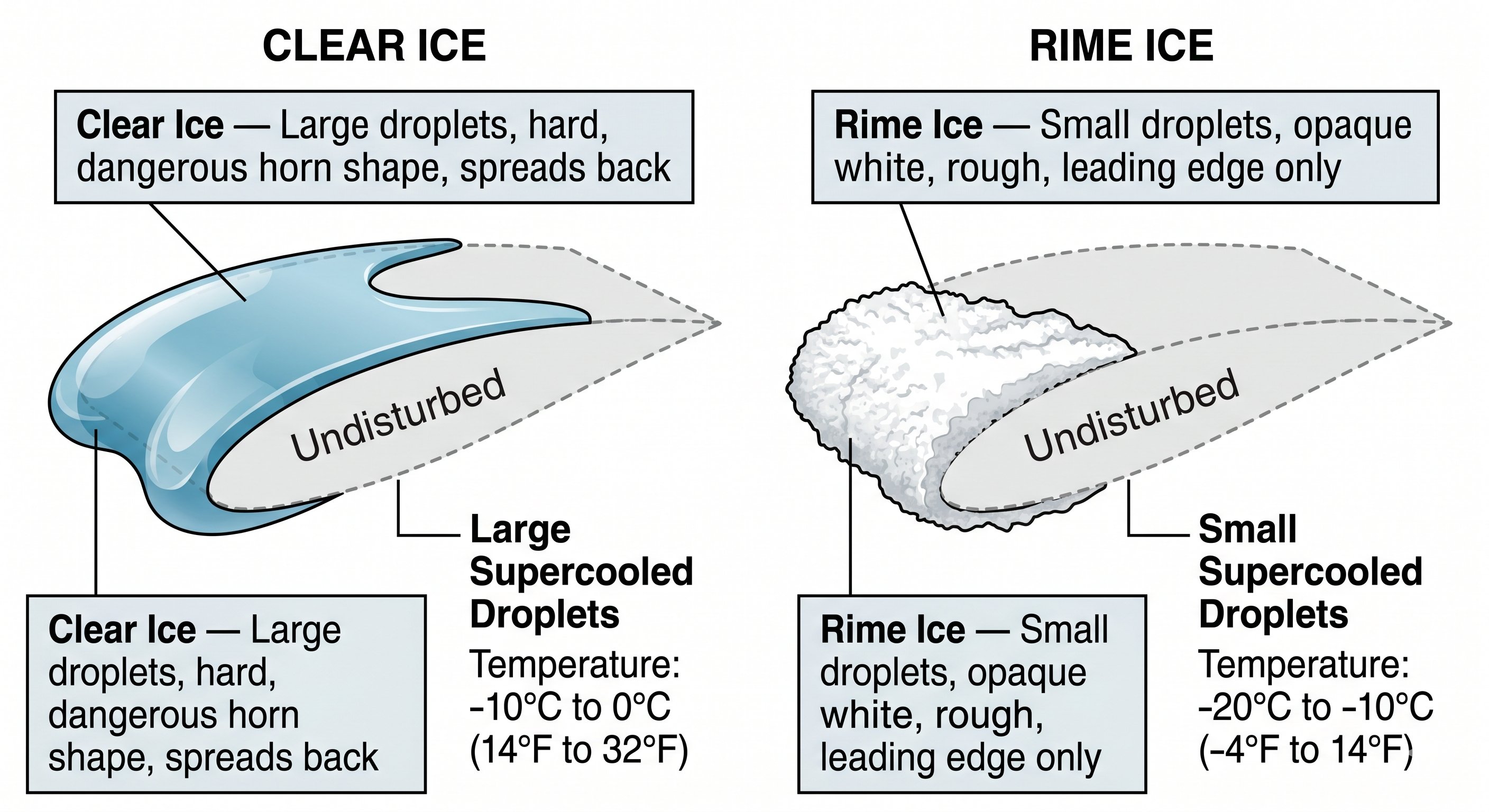 Icing types and their appearance
Clear ice (glaze ice) forms from freezing rain or large supercooled droplets. It is smooth, hard, and nearly transparent — difficult to see. It conforms closely to the airfoil shape initially but can form a dangerous horn or double horn shape on the leading edge. Clear ice is the most dangerous icing type because it is hardest to detect visually and spreads across more of the wing surface.
Rime ice forms from small supercooled droplets in stratiform clouds. It is white, opaque, and brittle — rough but confined mainly to the leading edge. Less aerodynamically disruptive than clear ice per unit thickness, but significant accumulations are still dangerous.
Mixed ice combines characteristics of both clear and rime, forming in conditions where droplet size varies. Common in flight through clouds near the freezing level.
The VFR icing rule: VFR aircraft without anti-ice or deice equipment must not fly in known icing conditions. Period. No matter how important the flight, no matter how short the iced-up segment appears on the forecast — ice accumulates faster than you expect, affects aircraft performance worse than you expect, and does not necessarily shed in warmer air below. If you encounter unexpected icing in VFR flight, turn immediately to warmer air or lower altitude.
How ice changes the airplane — the aerodynamic truth
Ice accretion changes the aircraft's aerodynamic characteristics in ways that are cumulative, unpredictable, and potentially catastrophic. Even a thin layer of frost or ice — as little as 1/8 inch — can:
- Reduce lift by up to 30% by disrupting the smooth airflow over the wing
- Increase drag by up to 40% by roughening the surface and disrupting the boundary layer
- Increase stall speed — sometimes dramatically and without warning
- Cause control surface effectiveness to degrade as ice builds on hinges and surfaces
- Add significant weight — ice is heavy, and accumulation on an airframe adds hundreds of pounds rapidly in severe conditions
The danger is that these changes happen gradually and may not be immediately obvious. The aircraft handles differently — requiring more back pressure to maintain altitude, showing slightly different roll response — but the changes are small at first. Then the stall speed has increased by 15 knots, and the pilot applies the same approach speed as always, and the aircraft stalls at what seemed like a safe margin.
Rime, clear, and mixed ice — practical differences
Rime ice: Forms in light, steady conditions with small water droplets. Looks white and opaque — milky appearance. Freezes immediately on contact, trapping air bubbles. Rime is rough but relatively predictable in its accumulation pattern. It adds to the leading edge of wings but doesn't conform around the entire airfoil.
Clear ice (glaze ice): Forms in heavy, warm-temperature icing conditions with large water droplets. Water doesn't freeze immediately — it runs back along the surface before freezing, creating a smooth, transparent, very dense ice sheet. Clear ice is the most dangerous type: it's heavier, harder to detect visually, and wraps around more of the airfoil, disrupting lift over a larger area.
Mixed ice: Combination of both, forming in conditions that transition between the two formation environments. Most icing encounters in actual flight are mixed.
The only correct response to inadvertent icing encounter
If you encounter icing conditions you didn't anticipate: exit the icing layer immediately. This means either climbing above it or descending below it — and getting there fast. Continuing to penetrate icing conditions hoping they'll improve is the accident chain. Every minute in icing adds more ice; the degradation compounds. The decisions to make immediately:
- Turn on pitot heat (if equipped) — blocked pitot tube from ice gives false airspeed
- Turn on any available deicing equipment — carburetor heat, wing deice boots if equipped
- Increase airspeed slightly — reduces the time each portion of leading edge is exposed to supercooled droplets, somewhat reducing accumulation rate
- Declare an emergency if needed — ATC can provide priority vectors to ice-free conditions or a closer airport
- Do not wait to see "how bad it gets" — exit immediately
Lesson 8 — Thunderstorms and the Go/No-Go Decision
Thunderstorm formation
A thunderstorm requires three ingredients acting simultaneously: sufficient moisture (water vapor to fuel cloud growth and precipitation), a lifting mechanism (a front, orographic lift, surface heating, or converging winds to force air upward), and atmospheric instability (the lapse rate allows air to continue rising once lifted). Remove any one ingredient and the thunderstorm cannot form or sustain itself.
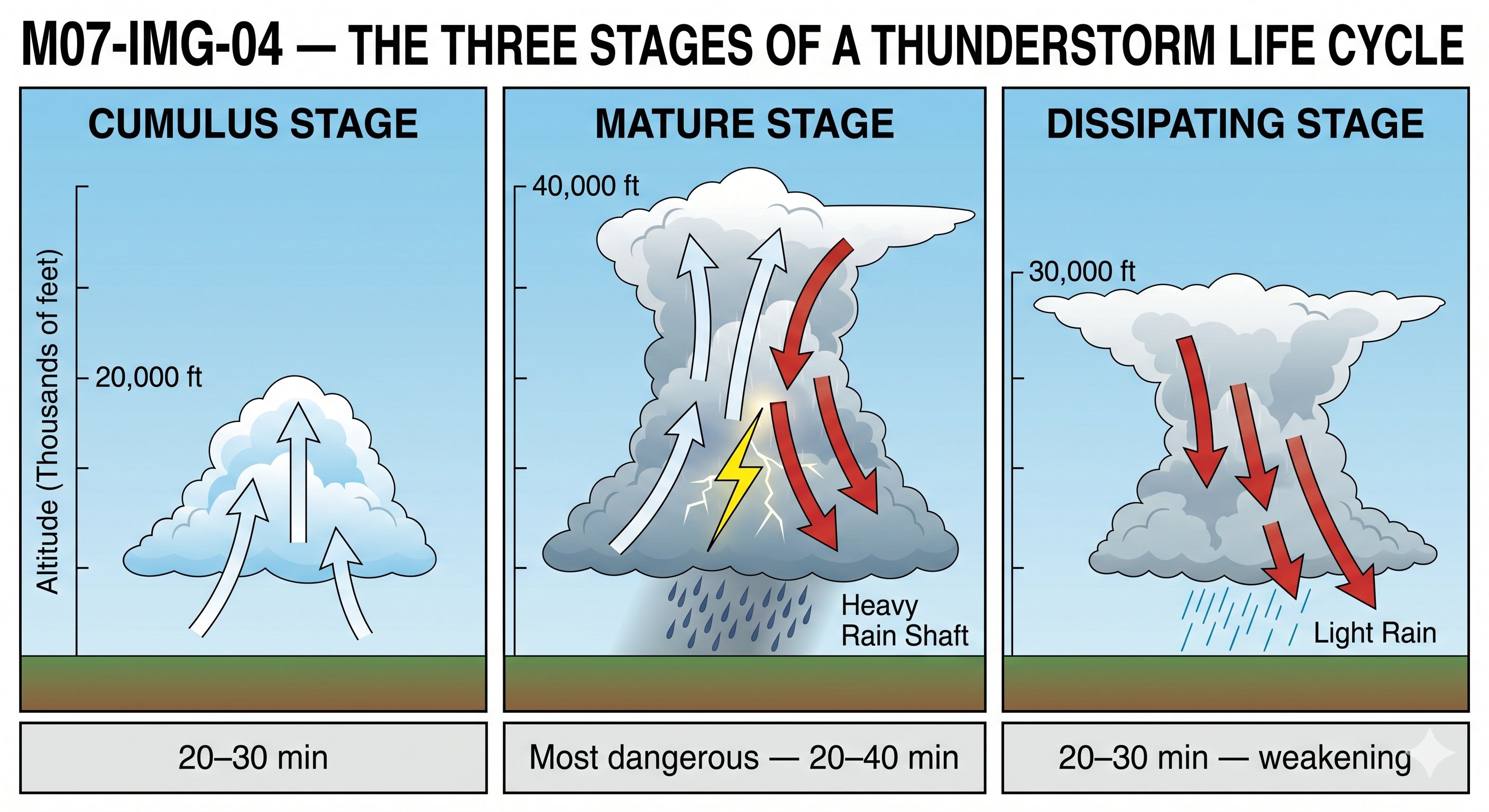 Thunderstorm hazards and avoidance
Turbulence: Both inside and outside the thunderstorm. Clear air turbulence extends up to 20 nm from severe cells. The anvil cloud can extend hundreds of miles downwind — don't fly under an anvil assuming you're safe because the cell is far away.
Hail: Can be thrown outward from a storm up to 20 nm. Hailstones the size of golf balls or larger have been documented. Even small hail at 150 knots airspeed can destroy propellers, windshields, and leading edges.
Wind shear and microbursts: Thunderstorm outflows create dangerous low-level wind shear. A microburst is a concentrated downdraft that creates an outflow of wind in all directions at the surface — capable of producing wind shear of 100 kts in a 1.5-mile span. Aircraft on approach or departure encountering a microburst may lose airspeed so rapidly that recovery is impossible.
Lightning: Strikes can damage aircraft structure, avionics, and temporarily blind the pilot. Although modern aircraft are designed to survive lightning strikes, small GA aircraft are less protected than transport category aircraft.
Thunderstorm avoidance rules — non-negotiable:
• Never penetrate a thunderstorm in any light aircraft under any circumstances
• Circumnavigate by at least 20 nautical miles from any severe cell
• Never attempt to fly between two cells with an apparent gap — gaps close; cells merge
• Never fly below a thunderstorm — the rain curtain and downburst are as dangerous as the cell
• If you see an anvil-topped cumulonimbus, the cell is in the mature stage — it is at maximum intensity
• At night, use lightning as a detector — consistent flashing in a direction means active cells there
The go/no-go weather decision framework
Weather go/no-go decisions fail most often not because pilots lack information, but because they allow external pressure to override what the information clearly indicates. The framework below separates the data collection from the decision to reduce rationalization.
Step 1 — Get a complete standard briefing. Call 1800wxbrief.com or use Leidos Flight Service. An app weather check is not a standard briefing. The briefer asks structured questions that ensure you receive all applicable information — AIRMETs, SIGMETs, TFRs, NOTAMs — that an app may not surface.
Step 2 — Check AIRMETs and SIGMETs for your route. Active Sierra on your route means IFR conditions are present. Active Zulu means icing. Convective SIGMET means thunderstorms. These are objective, operationally significant flags.
Step 3 — Review recent PIREPs. What are pilots actually reporting along your route right now? A pirep of severe turbulence at your planned altitude from 30 minutes ago is information no forecast can substitute for.
Step 4 — Assess the trend. Is weather improving or deteriorating? A ceiling at 1,800 ft that was 3,000 ft an hour ago is more concerning than a ceiling at 1,800 ft that was 1,500 ft an hour ago.
Step 5 — Identify alternates. Where would you divert if your destination goes IFR? Check their weather too.
Step 6 — Apply your personal minimums — the ones you set before you checked weather. If conditions are at or below your personal minimums, the decision is already made. No re-evaluation needed.
Step 7 — Give yourself explicit permission to cancel. Say it out loud if necessary: "The weather doesn't support this flight today." Landing is always an option. The sky sometimes isn't.
- Unstable atmosphere = vertical development, cumulus, thunderstorms, turbulence. Stable = stratus, fog, haze, smooth but IFR.
- Cold fronts: fast (20–35 kts), narrow violent band, rapid passage. Warm fronts: slow (10–15 kts), broad 500-1,000 mile weather shield, gradual deterioration.
- METAR groups in order: Station · Date/Time · Wind · Visibility · Weather · Sky · Temp/Dew · Altimeter · Remarks.
- Sky condition suffixes: FEW (1-2/8), SCT (3-4/8), BKN (5-7/8 = ceiling), OVC (8/8 = ceiling). Height in hundreds of feet AGL.
- VFR categories: VFR (ceiling 3,000+, vis 5+ SM) · MVFR (1,000–3,000 ft / 3–5 SM) · IFR (500–999 ft / 1–3 SM) · LIFR (below 500 ft / below 1 SM).
- TAF time groups: FM = permanent change. TEMPO = less than 1 hour at a time. PROB30 = 30% chance — be aware but don't plan on it.
- AIRMETs: Sierra (IFR), Tango (turbulence/wind), Zulu (icing). SIGMETs: severe conditions all aircraft. Convective SIGMET = no-go.
- Structural icing: visible moisture + 0°C to −20°C = risk. Clear ice most dangerous. VFR aircraft = avoid known icing conditions.
- Thunderstorms: 20 nm minimum circumnavigation. Never penetrate, gap-fly, or fly below. Microbursts most dangerous near surface.
- Go/no-go: full standard briefing → AIRMETs/SIGMETs → PIREPs → trend → alternates → personal minimums set in advance → explicit permission to cancel.